IMAGES TAKEN NEAR TO
Whistler Walk, World's End Estate, LONDON, SW10 0EP
Introduction
This page details the photographs taken nearby to Whistler Walk, World's End Estate, SW10 0EP by members of the Geograph project.
The Geograph project started in 2005 with the aim of publishing, organising and preserving representative images for every square kilometre of Great Britain, Ireland and the Isle of Man.

There are currently over 7.5m images from over14,400 individuals and you can help contribute to the project by visiting https://www.geograph.org.uk
Image Map
Images are licensed for reuse under creativecommons.org/licenses/by-sa/2.0
Notes
- Clicking on the map will re-center to the selected point.
- The higher the marker number, the further away the image location is from the centre of the postcode.
Image Listing (287 Images Found)
Images are licensed for reuse under creativecommons.org/licenses/by-sa/2.0
Image
Details
Distance
1
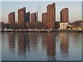
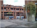
World's End Estate
The seven towers, connected by low-rise blocks, were completed in 1977. Chelsea Reach Tower and Greaves Tower (the nearest and furthest) are 20 storeys high; the rest are 18. Seen from across the river on the Thames Path near Paveley Drive.
Image: © Derek Harper
Taken: 16 Nov 2007
0.01 miles
2
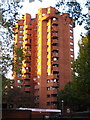
Block of flats at World's End
Part of the 1970s World's End social housing development, the brick clad towers look particularly pleasing in the low autumn afternoon sunlight.
Image: © Rod Allday
Taken: 16 Oct 2010
0.02 miles
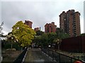
4
Tower Block Worlds End Estate
Taken from Burnaby Street
Image: © PAUL FARMER
Taken: 5 Feb 2009
0.03 miles
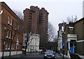
5
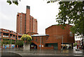
St John with St Andrew, 461 Kings Road, Chelsea & Flats
World's End Estate
Image: © John Salmon
Taken: 5 May 2011
0.03 miles
6
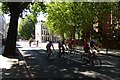
Cremorne Road
Cyclists taking part in the Ride London cycle ride head along Cremorne Road.
Image: © DS Pugh
Taken: 2 Aug 2015
0.04 miles
7
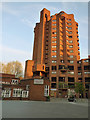
The World's End Estate, Chelsea
A modernist housing estate built 1969-1977, architect Eric Lyons. The design is fortress-like with tall corner towers and bastions around the perimeter. The estate is managed by Kensington & Chelsea TMO on behalf of the Royal Borough of Kensington and Chelsea.
Image: © Stephen Craven
Taken: 22 Apr 2018
0.05 miles
8
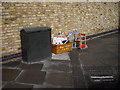
Harrys Toy Box
Dumped in street in Stadium Road
Image: © PAUL FARMER
Taken: 25 Mar 2009
0.05 miles
9
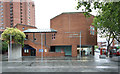
World's End Neighbourhood Advice Centre, Chelsea
Image: © PAUL FARMER
Taken: 24 Jan 2013
0.05 miles
10
St John with St Andrew, 461 Kings Road, Chelsea
Image: © John Salmon
Taken: 5 May 2011
0.06 miles