IMAGES TAKEN NEAR TO
Nabbs Close, STOKE-ON-TRENT, ST7 4YB
Introduction
This page details the photographs taken nearby to Nabbs Close, ST7 4YB by members of the Geograph project.
The Geograph project started in 2005 with the aim of publishing, organising and preserving representative images for every square kilometre of Great Britain, Ireland and the Isle of Man.

There are currently over 7.5m images from over14,400 individuals and you can help contribute to the project by visiting https://www.geograph.org.uk
Image Map
Images are licensed for reuse under creativecommons.org/licenses/by-sa/2.0
Notes
- Clicking on the map will re-center to the selected point.
- The higher the marker number, the further away the image location is from the centre of the postcode.
Image Listing (7 Images Found)
Images are licensed for reuse under creativecommons.org/licenses/by-sa/2.0
Image
Details
Distance
2
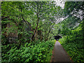
Kidsgrove Tunnel, Former Potteries Loop Line
https://en.wikipedia.org/wiki/Potteries_Loop_Line
Image: © Brian Deegan
Taken: 20 Jun 2021
0.15 miles
3
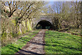
Birchenwood Tunnel
Birchenwood Tunnel was part of the Potteries Loop Line opened in 1875 between Etruria and Kidsgrove via Hanley and Tunstall. It was unusual in being built to accommodate three tracks. The line closed to passengers in 1964 although this section continued to be used for freight until 1976. It is now a cycleway and footpath.
Image: © Stephen McKay
Taken: 24 Mar 2017
0.16 miles
4
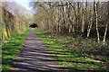
Former Potteries Loop Line, near Kidsgrove
The Potteries Loop Line ran from Etruria to Kidsgrove via Hanley and Tunstall. Passenger services were withdrawn in 1964 although freight continued on some sections until the mid-1970s. Today this stretch has been converted into a footpath and cycleway.
Image: © Stephen McKay
Taken: 24 Mar 2017
0.17 miles
5
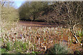
Pond near Birchenwood Tunnel
Adjacent to the former Potteries Loop railway, now a footpath and cycleway, is this orange pond. The colour of the water is caused by ironstone leeching and is common in the Kidsgrove area.
Image: © Stephen McKay
Taken: 24 Mar 2017
0.19 miles
6
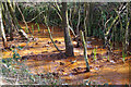
Stream beside the Potteries Loop Line
This stream (not named on the map) follows the old route of the Potteries Loop Line - now the Scotia Valley Greenway, a path and cycleway - for some distance east of Kidsgrove. Its colour looks alarming, but this is caused by ironstone leeching, a phenomenon that also affects the Trent & Mersey Canal in the area.
Image: © Stephen McKay
Taken: 24 Mar 2017
0.23 miles
7
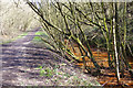
Former Potteries Loop Line east of Kidsgrove
The old railway which once ran from Etruria to Kidsgrove via Hanley and Tunstall is now a footpath and cycleway. Here it is accompanied by a stream coloured orange by the effects of ironstone leeching.
Image: © Stephen McKay
Taken: 24 Mar 2017
0.24 miles