IMAGES TAKEN NEAR TO
Bernard Grove, STOKE-ON-TRENT, ST3 7NZ
Introduction
This page details the photographs taken nearby to Bernard Grove, ST3 7NZ by members of the Geograph project.
The Geograph project started in 2005 with the aim of publishing, organising and preserving representative images for every square kilometre of Great Britain, Ireland and the Isle of Man.

There are currently over 7.5m images from over14,400 individuals and you can help contribute to the project by visiting https://www.geograph.org.uk
Image Map (Loading...)


Getting Data...Please wait
Leaflet Map data © OpenStreetMap
Images are licensed for reuse under creativecommons.org/licenses/by-sa/2.0
Notes
- Clicking on the map will re-center to the selected point.
- The higher the marker number, the further away the image location is from the centre of the postcode.
Image Listing (11 Images Found)
Images are licensed for reuse under creativecommons.org/licenses/by-sa/2.0
Image
Details
Distance
1
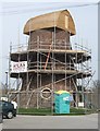
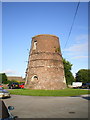
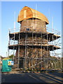
Meir Heath Windmill restoration
The wood has weathered a little in the last month since Image
If the Meir Heath Windmill Preservation Group can raise £20000 they plan to waterproof render the walls and repair the guttering. Plans are to open this as an information centre.
The Grade 2 listed mill was built in the 18th century. It remained in use until the late 1890s and was later a water tower. The sails were removed during service as a wartime observation post by the Home Guard.
Image: © John M
Taken: 10 Apr 2010
0.16 miles
2
The Windmill at Meir Heath
http://www.geograph.org.uk/photo/4891983 http://www.geograph.org.uk/photo/4891988
Image: © Ian S
Taken: 29 Mar 2016
0.18 miles
3
The Windmill at Meir Heath
http://www.geograph.org.uk/photo/4891988 http://www.geograph.org.uk/photo/4891982
Image: © Ian S
Taken: 29 Mar 2016
0.18 miles
4
The Windmill at Meir Heath
http://www.geograph.org.uk/photo/4891982 http://www.geograph.org.uk/photo/4891983
Image: © Ian S
Taken: 29 Mar 2016
0.19 miles
5
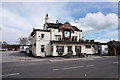
Meir Heath windmill
The shell of this windmill was rescued and stabilised from a dilapidated state in 2002, when the concrete cap was repaired and the iron bands around the brickwork were restored. A local group was formed at that time to try and look after it. The mill stands in the carpark of a pub called, with great imagination, The Windmill.
Image: © Richard Law
Taken: 15 Jul 2009
0.19 miles
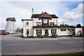
6
Old Corn Windmill Tower
This Wind Cornmill Tower stands in the carpark of the windmill inn at Meir Heath
Image: © Andrew Milward
Taken: 19 Nov 2004
0.19 miles
7
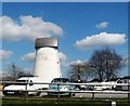
Meir Heath, windmill
In the car park of The Windmill public house; the mill is C18, and has also served as water tank, Home Guard post and communications tower; now awaiting restoration. http://www.meirheathwindmill.com/Meir-Heath-Windmill
Image: © Mike Faherty
Taken: 8 Oct 2012
0.20 miles
9
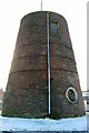
Restoration work underway on the Meir Heath windmill
Yes - it does look exactly like they've deposited a small boat upside-down on the top.
Update July 2011:- The plan is to make the mill waterproof, and so a Lime slurry waterproof render, suggested by the Stafford Borough Conservation Officer, will be eventually put onto the windmill tower. The Guttering will be aluminium and a soakaway French drain will be installed around the base. Thanks to Gill Swift, the Preservation Group Project Officer, for this detail.
The same mill structure a few months previously Image
Image: © Richard Law
Taken: 9 Mar 2010
0.20 miles
10
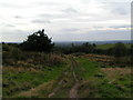
Rough Close
Just visible (if you look VERY hard in a direct continuation from the path!) is The Wrekin, about 30 miles away
Image: © Linda Mellor
Taken: 26 Sep 2005
0.20 miles