IMAGES TAKEN NEAR TO
Redhill Road, STONE, ST15 8BE
Introduction
This page details the photographs taken nearby to Redhill Road, ST15 8BE by members of the Geograph project.
The Geograph project started in 2005 with the aim of publishing, organising and preserving representative images for every square kilometre of Great Britain, Ireland and the Isle of Man.

There are currently over 7.5m images from over14,400 individuals and you can help contribute to the project by visiting https://www.geograph.org.uk
Image Map
Images are licensed for reuse under creativecommons.org/licenses/by-sa/2.0
Notes
- Clicking on the map will re-center to the selected point.
- The higher the marker number, the further away the image location is from the centre of the postcode.
Image Listing (124 Images Found)
Images are licensed for reuse under creativecommons.org/licenses/by-sa/2.0
Image
Details
Distance
1
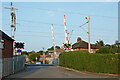
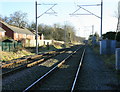
Church Lane level crossing in Stone, Staffordshire
Looking north-east, the railway line between Rugeley and Stoke-on-Trent crosses here. Railway bureaucracy causes confusion because Church Street changes to Redhill Road here. There is no Church Lane!
Image]
Image: © Roger Kidd
Taken: 10 Sep 2014
0.02 miles
2
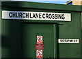
2008 : Control box at Church Lane level crossing
The identification plate reads SOT27M137. The mileage on this route is measured from the junction at Cheadle Hulme (just south of Stockport) where the North Staffordshire line via Stoke on Trent diverges from the original London & North Western line via Crewe. The official distance to the crossing is documented as 27 miles 63 chains (27 miles 1386 yards). The other signs forbid the use of "portable" telephones and smoking, and offer advice to anyone wishing to enter.
Update 2021: A further curiosity is that despite the name of the crossing there is no Church Lane in the village. Church Road runs parallel to the railway, just south and west of the level crossing, but the road that actually crosses the line is called Redhill Road. The parish church of St Michael, from which the crossing is presumably named, stands some way further to the west.
Image: © Maurice Pullin
Taken: 26 Dec 2008
0.03 miles
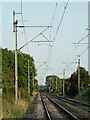
3
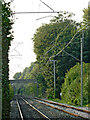
Railway in Stone Staffordshire
Looking south-east towards Rugeley in warm evening sunlight, this is the line from Stoke-on-Trent, seen from the Church Lane level crossing. Railway bureaucracy causes confusion here because Church Street changes to Redhill Road. There is no Church Lane!
The houses are in The Sidings, so one is tempted to surmise what preceded the housing there. However, Victorian maps reveal that there were no railway sidings here, just small fields.
Image: © Roger Kidd
Taken: 10 Sep 2014
0.05 miles
4
Railway in Stone Staffordshire
Looking south-east towards Rugeley, this is the line from Stoke-on-Trent, seen from the Church Street level crossing. The railway authorities insist on naming this Church Lane Crossing.
Image: © Roger Kidd
Taken: 10 Sep 2014
0.05 miles
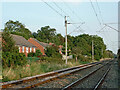
5
2008 : Church Lane Railway Level Crossing, Stone
Looking toward Rugeley and Lichfield.
Image: © Maurice Pullin
Taken: 26 Dec 2008
0.06 miles
7
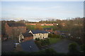
Converted Mill buildings
A view from Coppice Road, Stone, looking down the hill to old mill buildings that are now converted to flats. The church in the background is St Michael's.
Image: © Stephen Pearce
Taken: 21 Apr 2007
0.07 miles
8

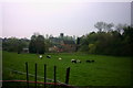
Stone Mill, Stone
View from the other side at lade level. Now a hotel and restaurant.
Image: © Chris Allen
Taken: 26 Jan 2008
0.07 miles
9
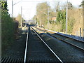
Railway in Stone Staffordshire
Looking north-west towards Stone station and Stoke-on-Trent, this is the line from Rugeley, seen with telephoto assistance from the Church Lane level crossing. The bridge ahead carries a footpath.
Railway bureaucracy causes confusion here because Church Street changes to Redhill Road. There is no Church Lane!
Image: © Roger Kidd
Taken: 10 Sep 2014
0.07 miles
10
2008 : Church Lane Crossing looking north east
Stone station is little more than half a mile in this direction but there is no platform on this line. The nearest bridge carries a footpath to Granville Terrace; the bridge beyond it carries the A520 to Leek.
Image: © Maurice Pullin
Taken: 26 Dec 2008
0.08 miles