IMAGES TAKEN NEAR TO
Altona Close, STONE, ST15 8AR
Introduction
This page details the photographs taken nearby to Altona Close, ST15 8AR by members of the Geograph project.
The Geograph project started in 2005 with the aim of publishing, organising and preserving representative images for every square kilometre of Great Britain, Ireland and the Isle of Man.

There are currently over 7.5m images from over14,400 individuals and you can help contribute to the project by visiting https://www.geograph.org.uk
Image Map (Loading...)


Getting Data...Please wait
Leaflet Map data © OpenStreetMap
Images are licensed for reuse under creativecommons.org/licenses/by-sa/2.0
Notes
- Clicking on the map will re-center to the selected point.
- The higher the marker number, the further away the image location is from the centre of the postcode.
Image Listing (27 Images Found)
Images are licensed for reuse under creativecommons.org/licenses/by-sa/2.0
Image
Details
Distance
1
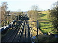
2008 : From the railway bridge on Pingle Lane
Looking north west toward Stone.
Image: © Maurice Pullin
Taken: 26 Dec 2008
0.07 miles
2
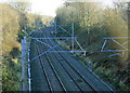
2008 : South east from Pringle Lane railway bridge
The former L.M.S. line from Stoke on Trent heading toward Stafford having passed through Stone.
Image: © Maurice Pullin
Taken: 26 Dec 2008
0.17 miles
3
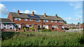
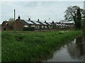
Housing in Stone, Staffordshire
The canalside housing is in Sycaore Road, and seen from the canal towpath.
Image: © Roger Kidd
Taken: 29 Jul 2015
0.21 miles
4
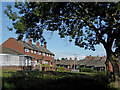
Social housing in Stone, Staffordshire
The housing is in Sycamore Road and Crompton Road, and is seen from the canal towpath.
Image: © Roger Kidd
Taken: 29 Jul 2015
0.21 miles
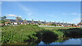
5

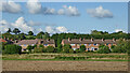
Canal and housing in Stone, Staffordshire
Looking south-east towards Weston, Great Haywood and Burton-on-Trent. The housing is in Willow Road (off Priory Road).
Image: © Roger Kidd
Taken: 29 Jul 2015
0.21 miles
6
Housing and farmland in Stone, Staffordshire
A telephoto assisted image, looking east towards Willow Road houses (250 metres away) from the southern edge of Westbridge Park. The Trent and Mersey Canal crosses the scene along the line of trees in front of the housing.
Image: © Roger Kidd
Taken: 29 Jul 2015
0.21 miles
7
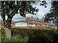
Bungalows with solar panels
Crompton Road, Stone.
Image: © Christine Johnstone
Taken: 2 May 2023
0.21 miles
8
Housing in Stone, Staffordshire
This housing is in Sycamore Road, and seen from the Trent and Mersey Canal.
Image: © Roger Kidd
Taken: 3 Aug 2015
0.22 miles
9
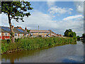
Trent and Mersey Canal in Stone, Staffordshire
Looking south-east towards Weston, Great Haywood and Burton-on-Trent. Sheltered housing on the left is in Crompton Road. Further ahead the housing is in Willow Road.
Image: © Roger Kidd
Taken: 29 Jul 2015
0.22 miles
10
Sycamore Road housing in Stone, Staffordshire
This sheltered housing row is in Sycamore Road, off Priory Road near the Trent and Mersey Canal.
Image: © Roger Kidd
Taken: 29 Jul 2015
0.22 miles