
IMAGES TAKEN NEAR TO
High Street, UTTOXETER, ST14 7JQ
Introduction
This page details the photographs taken nearby to High Street, ST14 7JQ by members of the Geograph project.
The Geograph project started in 2005 with the aim of publishing, organising and preserving representative images for every square kilometre of Great Britain, Ireland and the Isle of Man.

There are currently over 7.5m images from over14,400 individuals and you can help contribute to the project by visiting https://www.geograph.org.uk
Image Map
Images are licensed for reuse under creativecommons.org/licenses/by-sa/2.0
Notes
- Clicking on the map will re-center to the selected point.
- The higher the marker number, the further away the image location is from the centre of the postcode.
Image Listing (107 Images Found)
Images are licensed for reuse under creativecommons.org/licenses/by-sa/2.0
Image
Details
Distance
1
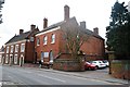
Former Drill Hall - High Street
18th Century house with passageway through to hall at rear. Now used by council department.
In 1914 drill station for the Staffordshire Yeomanry and base for North Staffordshire Regiment.
Image: © John M
Taken: 26 Feb 2014
0.00 miles
2
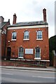
Former Drill Hall - High Street
18th Century house with passageway through to hall at rear. Now used by council department.
In 1914 drill station for the Staffordshire Yeomanry and base for North Staffordshire Regiment.
Image: © John M
Taken: 26 Feb 2014
0.00 miles
3
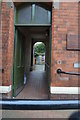
Passageway to the drill hall
The passageway allows access into the drill hall yard.
18th Century house with passageway through to hall at rear. Now used by council department.
Image
In 1914 drill station for the Staffordshire Yeomanry and base for North Staffordshire Regiment.
Image: © John M
Taken: 26 Feb 2014
0.00 miles
4
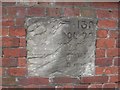
Old Milestone, A522 (was A50), High Street, Uttoxeter
The milestone is built into the front garden wall of the Manor House on the west side of the road. Parish of Uttoxeter (East Staffordshire District). Carved stone plaque, Wall stone design, erected by the Uttoxeter & Blythe Marsh turnpike trust in the 19th century.
Inscription reads:-
(LONDON) 139
(LIVERPO)OL 7(0)
(NEWCASTLE 18 MILES)
(UTTOXETER) 0 MIL(ES) :
Grade II listed. List Entry Number: 1374330
https://historicengland.org.uk/listing/the-list/list-entry/1374330
Milestone Society National ID: ST_NCUT19
Image: © Mike Faherty
Taken: 21 Apr 2008
0.02 miles
6
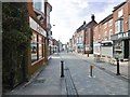
Uttoxeter High Street
Several good remaining Victorian buildings, and independent businesses; but suffering like many similar small towns from out-of-town shopping centres without parking charges.
Image: © Mike Faherty
Taken: 12 May 2018
0.06 miles
7
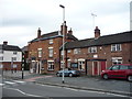
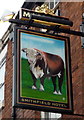
The Smithfield Hotel, Uttoxeter
On High Street.
Image: © JThomas
Taken: 27 Aug 2016
0.06 miles
8
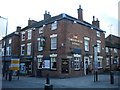
The Smithfield Hotel, Uttoxeter
On the corner of Smithfield Road (right) and High Street.
Image: © Richard Vince
Taken: 11 Jan 2014
0.06 miles
9
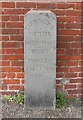
Old Boundary Marker by the A522, Bradley Street, Uttoxeter
Turnpike Terminus Marker by the A522, in parish of Uttoxeter (East Staffordshire District), Bradley Street, in front of brick wall.
Inscription reads:-
TERMINATION
OF THE
DERBY ROAD
.......
DERBY
18 MILES
ONE¼, & 50YDS
Grade II listed.
List Entry Number: 1038782 https://historicengland.org.uk/listing/the-list/list-entry/1038782
Surveyed
Milestone Society National ID: ST_UTDE00t
Image: © Mike Faherty
Taken: 21 Apr 2008
0.07 miles
10
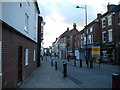
High Street, Uttoxeter
Looking towards the market place from Bradley Street.
Image: © Richard Vince
Taken: 11 Jan 2014
0.07 miles