IMAGES TAKEN NEAR TO
Ashdown Crescent, BENFLEET, SS7 2LJ
Introduction
This page details the photographs taken nearby to Ashdown Crescent, SS7 2LJ by members of the Geograph project.
The Geograph project started in 2005 with the aim of publishing, organising and preserving representative images for every square kilometre of Great Britain, Ireland and the Isle of Man.

There are currently over 7.5m images from over14,400 individuals and you can help contribute to the project by visiting https://www.geograph.org.uk
Image Map
Images are licensed for reuse under creativecommons.org/licenses/by-sa/2.0
Notes
- Clicking on the map will re-center to the selected point.
- The higher the marker number, the further away the image location is from the centre of the postcode.
Image Listing (10 Images Found)
Images are licensed for reuse under creativecommons.org/licenses/by-sa/2.0
Image
Details
Distance
1
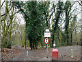
Pick a route
Straight ahead is the bridleway that goes to Poors Lane North. There are also gates into Dodds Grove and the Great Wood. To the right is one of the entrances to the Great Wood.
Image: © terry joyce
Taken: 28 Jan 2011
0.07 miles
2
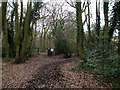
Great Wood
This entrance to Great Wood is at the end Poors Lane.
Image: © terry joyce
Taken: 28 Jan 2011
0.09 miles
3
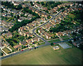
Daws Heath Road and Hadleigh allotments
Daws Heath Road runs across from left to right, with Sherwood Crescent parallel and above it, turning up towards the top at the left hand end. Hadleigh allotments lie in the foreground, with part of the John Burrows Recreation Ground to the right.
Image: © Edward Clack
Taken: 8 Aug 1988
0.14 miles
4
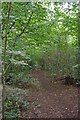
Path Through Hadleigh Great Wood
One of numerous paths criss crossing Hadleigh Great Wood which is part of Belfairs Nature Reserve http://www.wildessex.net/sites/Belfairs%20Park.htm
Image: © Glyn Baker
Taken: 28 Aug 2011
0.15 miles
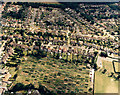
5
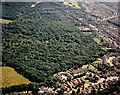
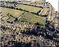
Aerial view of Belfairs Nature Reserve, Hadleigh
Belfairs Nature reserve occupies much of the centre and top left of the picture. Scrub Lane runs across the upper right corner, with Shepherds Walk and Shepherds Close in the foreground.
Image: © Edward Clack
Taken: 21 Jun 1989
0.16 miles
6
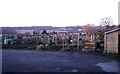
Hadleigh Allotments
These allotments in Hadleigh are to the north of the recreation ground on Heath Road. The houses in the background are in Dalwood Gardens.
Image: © Glyn Baker
Taken: 28 Jan 2006
0.16 miles
7
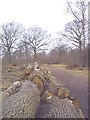
Felled Oaks
Significant clearance including these oak standards in S.W of wood.
Image: © John Myers
Taken: 8 Feb 2004
0.18 miles
8
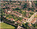
Aerial view of Scrub Lane and Rectory Road, Hadleigh
Scrub Lane runs across the lower right of the picture. Rectory Road runs across the lower left. At the junction of these (bottom-centre) there are traffic lights. The green area at the bottom left is the southern part of the John Burrows Recreation Ground.
Image: © Edward Clack
Taken: 27 Jun 1987
0.20 miles
9
Aerial view of Scrub Lane and Greenacres, Hadleigh
Scrub Lane runs from the lower left to the mid-right. Greenacres runs from half-way along this upwards and then to the right. The playing fields in the foreground are of Hadleigh Infants School.
Image: © Edward Clack
Taken: 13 Jun 1988
0.21 miles
10
Aerial view between Hadleigh and Daws Heath
This is the area just north of Image The road across the centre is Daws Heath Road, running between Hadleigh to the left (south) and Daws Heath to the right (north). The patchwork area just above centre are allotments, seen at ground level in Image To the left of these, the open area is part of the John Burrows recreation grounds. The square at the left centre is a bowling green. The date given here is approximate.
Image: © Edward Clack
Taken: Unknown
0.22 miles