IMAGES TAKEN NEAR TO
Lower Lambricks, RAYLEIGH, SS6 8DB
Introduction
This page details the photographs taken nearby to Lower Lambricks, SS6 8DB by members of the Geograph project.
The Geograph project started in 2005 with the aim of publishing, organising and preserving representative images for every square kilometre of Great Britain, Ireland and the Isle of Man.

There are currently over 7.5m images from over14,400 individuals and you can help contribute to the project by visiting https://www.geograph.org.uk
Image Map
Images are licensed for reuse under creativecommons.org/licenses/by-sa/2.0
Notes
- Clicking on the map will re-center to the selected point.
- The higher the marker number, the further away the image location is from the centre of the postcode.
Image Listing (29 Images Found)
Images are licensed for reuse under creativecommons.org/licenses/by-sa/2.0
Image
Details
Distance
1
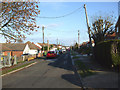
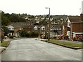
Hambro Avenue
This road links Hambro Hill with Downhall Road via Image It has approximately 50 properties of varying types, bungalows, houses, detached and semi detached.
Image: © terry joyce
Taken: 29 Nov 2010
0.05 miles
2
Hambro Avenue
This road links Hambro Hill with Downhall Road via Image It has approximately 50 properties of varying types, bungalows, houses, detached and semi detached.
Image: © terry joyce
Taken: 29 Nov 2010
0.09 miles
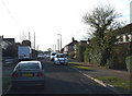
3
Preston Gardens
This short section of road has between 8 to 10 properties and links Downhall Road to Hambro Avenue. I was standing near the junction of Hambro Avenue and approximately 40 metres behind where I was standing is the London to Southend railway line.
Image: © terry joyce
Taken: 29 Nov 2010
0.09 miles
4
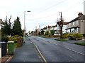
Downhall Road
This road is the main access road between Rayleigh and Hullbridge.
Image: © terry joyce
Taken: 26 Nov 2012
0.12 miles
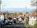
5
Houses along Upper Lambricks
This part of the road is quite high and has a good view over Rayleigh, which is seen in the distance.
Image: © Robert Edwards
Taken: 13 Aug 2008
0.13 miles
6
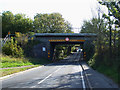
Railway bridge on Hambro Hill, Rayleigh
Image: © David Howard
Taken: 26 Jul 2020
0.13 miles
7
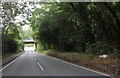
Railway Bridge
This railway bridge takes the Southend Victoria to London Liverpool Street line over Hambro Hill in Rayleigh.
Image: © terry joyce
Taken: 21 Oct 2010
0.14 miles
8
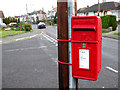
George VI Postbox
On the junction of Deepdene Avenue and Downhall Road.
George VI 1936-1952.
Image: © terry joyce
Taken: 22 Nov 2010
0.15 miles
9
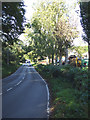
Hambro Hill
This is probably the steepest hill in Rayleigh. Behind the trees to the right is R E Wood & Sons Tree felling contractors.
Image: © terry joyce
Taken: 21 Oct 2010
0.15 miles
10
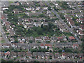
Centisquare Aerial
Centisquare TQ808921 starts in the gardens of Brixham Close and Downhall Road, which is the green area in the centre of the picture.
Image: © terry joyce
Taken: 29 Jun 2012
0.15 miles