IMAGES TAKEN NEAR TO
Cranley Gardens, SOUTHEND-ON-SEA, SS3 9JP
Introduction
This page details the photographs taken nearby to Cranley Gardens, SS3 9JP by members of the Geograph project.
The Geograph project started in 2005 with the aim of publishing, organising and preserving representative images for every square kilometre of Great Britain, Ireland and the Isle of Man.

There are currently over 7.5m images from over14,400 individuals and you can help contribute to the project by visiting https://www.geograph.org.uk
Image Map
Images are licensed for reuse under creativecommons.org/licenses/by-sa/2.0
Notes
- Clicking on the map will re-center to the selected point.
- The higher the marker number, the further away the image location is from the centre of the postcode.
Image Listing (10 Images Found)
Images are licensed for reuse under creativecommons.org/licenses/by-sa/2.0
Image
Details
Distance
3
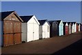
Shoebury Promenade
Beach huts closed for the season stand weather-beaten against a January sky. No-one is around at this time of year.
Image: © Julieanne Savage
Taken: 1 Jan 2007
0.14 miles
4

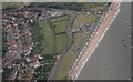
Southend-on-Sea from the air
The town is cloud free, but the rest of Essex is obscured by clouds. Viewed from a Brussels bound flight from Prestwick.
Image: © Thomas Nugent
Taken: 1 Mar 2010
0.14 miles
6
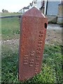
Old Boundary Marker
Municipal Boundary Marker in front of beach huts between the road and the beach opposite junction of Maplin Way and Shoebury Common Road. Now entirely in the boundary of Southend on Sea unitary authority. In raised lettering BOROUGH OF SOUTHEND / ON SEA / 1908 and URBAN DISTRICT / OF SHOEBURYNESS.
Milestone Society National ID: EX_SOUS07pb
Image: © R Rothwell
Taken: 10 Apr 2020
0.19 miles
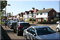
7
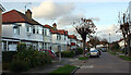
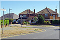
Junction of Church Road & Thorpedene Gardens, Shoeburyness
Image: © David Kemp
Taken: 22 Feb 2018
0.21 miles
8
St Andrew's Road, Shoeburyness
Oddly, the nearby St Andrew's church is in Church Road which runs parallel to St Andrew's Road. The reason may be that St Andrew's Road was at the time of its construction the nearest made-up road to the church whereas Church Road is of much more modern construction. See Geograph Image
Image: © David Kemp
Taken: 22 Feb 2018
0.21 miles
9
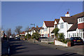
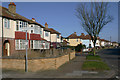
Church Road, Shoeburyness
The western end of Church Road is seen here where it meets Maplin Way, a short distance inland from the seafront. Note the distinctive style of road name signs used in Southend on Sea.
Image: © Stephen McKay
Taken: 11 Aug 2022
0.21 miles
10
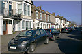
Church Road, Shoeburyness
Taken outside St Andrew's church (left) near the corner of Richmond Avenue. Although St Andrew's has very much the look of a country church both inside and out it is surrounded on all sides by suburban development such as this.
Image: © David Kemp
Taken: 13 Apr 2014
0.25 miles