IMAGES TAKEN NEAR TO
St. Andrews Road, SOUTHEND-ON-SEA, SS3 9JF
Introduction
This page details the photographs taken nearby to St. Andrews Road, SS3 9JF by members of the Geograph project.
The Geograph project started in 2005 with the aim of publishing, organising and preserving representative images for every square kilometre of Great Britain, Ireland and the Isle of Man.

There are currently over 7.5m images from over14,400 individuals and you can help contribute to the project by visiting https://www.geograph.org.uk
Image Map
Images are licensed for reuse under creativecommons.org/licenses/by-sa/2.0
Notes
- Clicking on the map will re-center to the selected point.
- The higher the marker number, the further away the image location is from the centre of the postcode.
Image Listing (33 Images Found)
Images are licensed for reuse under creativecommons.org/licenses/by-sa/2.0
Image
Details
Distance
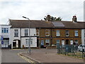
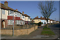
2
St Andrew's Road, Shoeburyness
Oddly, the nearby St Andrew's church is in Church Road which runs parallel to St Andrew's Road. The reason may be that St Andrew's Road was at the time of its construction the nearest made-up road to the church whereas Church Road is of much more modern construction. See Geograph Image
Image: © David Kemp
Taken: 22 Feb 2018
0.07 miles
4
Junction of Church Road & Thorpedene Gardens, Shoeburyness
Image: © David Kemp
Taken: 22 Feb 2018
0.12 miles
5
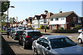
Church Road, Shoeburyness
Taken outside St Andrew's church (left) near the corner of Richmond Avenue. Although St Andrew's has very much the look of a country church both inside and out it is surrounded on all sides by suburban development such as this.
Image: © David Kemp
Taken: 13 Apr 2014
0.15 miles
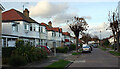
6
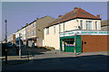
West Road, Shoeburyness
Taken from St Andrew's Road. Once a thriving shopping street, West Road has become a shadow of its former self over the years following the closure of the Shoebury Garrison in 1976 and the opening of the nearby Asda superstore in 1981.
Image: © David Kemp
Taken: 22 Feb 2018
0.17 miles
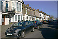
7
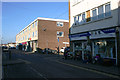
West Road, Shoeburyness
Not so long ago West Road was a thriving shopping street. But with the closure of the Shoebury Garrison in 1976 and the opening the Asda superstore ten minutes' walk away five years later, West Road went into decline. Many of the former retail premises are now occupied by charity shops, fast food outlets or closed altogether. The optimistically and inaccurately named Seaview Road can be seen on the right.
Image: © David Kemp
Taken: 22 Feb 2018
0.17 miles
8
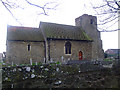
St Andrews' C of E Church, Shoeburyness
Taken from Church Road.
Image: © Julieanne Savage
Taken: 9 Dec 2006
0.18 miles
9
Shoeburyness & Thorpe Bay Baptist Church
This is the Thorpedene Gardens frontage of the church. Although the church has been in existence since 1910 its present buildings date from 2006.
Image: © David Kemp
Taken: 16 Apr 2019
0.18 miles