IMAGES TAKEN NEAR TO
Fort William Road, BASILDON, SS16 5JX
Introduction
This page details the photographs taken nearby to Fort William Road, SS16 5JX by members of the Geograph project.
The Geograph project started in 2005 with the aim of publishing, organising and preserving representative images for every square kilometre of Great Britain, Ireland and the Isle of Man.

There are currently over 7.5m images from over14,400 individuals and you can help contribute to the project by visiting https://www.geograph.org.uk
Image Map
Images are licensed for reuse under creativecommons.org/licenses/by-sa/2.0
Notes
- Clicking on the map will re-center to the selected point.
- The higher the marker number, the further away the image location is from the centre of the postcode.
Image Listing (13 Images Found)
Images are licensed for reuse under creativecommons.org/licenses/by-sa/2.0
Image
Details
Distance
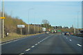
1
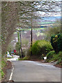
Bells Hill Road
This road runs from the slip road off the A13 at Vange to join Nethermayne (A176) near Basildon Hospital.
Before Nethermayne (A176) was built sometime in the 1960's this was the main road into Basildon from Fobbing.
Image: © terry joyce
Taken: 19 Jan 2012
0.09 miles
4
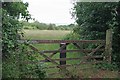
A Gate to Langdon Hills
A hay meadow a stones throw from Basildon Hospital part of the Langdon Hills complex of reserves. See inside the gate at Image
Image: © Glyn Baker
Taken: 15 Jun 2020
0.16 miles
5
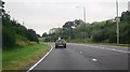
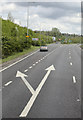
London Road Vange
Looking towards Nether Mayne.
Image: © David Howard
Taken: 25 May 2021
0.18 miles
6
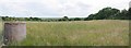
Hay Meadow Panorama
Looking towards Coryton and DP World.
Image: © Glyn Baker
Taken: 15 Jun 2020
0.18 miles
7

Hawkesbury Bush
Looking towards the Bush, on top of the hill. This is at the eastern end of Langdon Hills Country Park. There is a trig point on the summit (70 m), so the bushes did not always extend over the top of the hill.
Image: © Robin Webster
Taken: 23 Apr 2017
0.18 miles
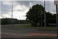
9
Vange Turn-off
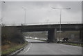
Slip road near Vange giving access to the A176 and the B1464 from the A13.
Image: © Martin Addison
Taken: 25 Apr 2015
0.19 miles