IMAGES TAKEN NEAR TO
Pot Inn Close, WICKFORD, SS11 7FZ
Introduction
This page details the photographs taken nearby to Pot Inn Close, SS11 7FZ by members of the Geograph project.
The Geograph project started in 2005 with the aim of publishing, organising and preserving representative images for every square kilometre of Great Britain, Ireland and the Isle of Man.

There are currently over 7.5m images from over14,400 individuals and you can help contribute to the project by visiting https://www.geograph.org.uk
Image Map
Images are licensed for reuse under creativecommons.org/licenses/by-sa/2.0
Notes
- Clicking on the map will re-center to the selected point.
- The higher the marker number, the further away the image location is from the centre of the postcode.
Image Listing (7 Images Found)
Images are licensed for reuse under creativecommons.org/licenses/by-sa/2.0
Image
Details
Distance
1
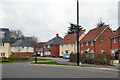
Houses on new St Luke's Park development
Still in progress, this is a redevelopment of the grounds of the former Runwell Hospital, a mental hospital.
Image: © Robin Webster
Taken: 25 Mar 2018
0.03 miles
2
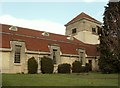
St. Luke's church at Runwell Hospital
The hospital was founded in 1934 as a mental hospital and stayed that way until 1955.
Image: © Robert Edwards
Taken: 9 Apr 2008
0.08 miles
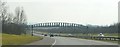
4
Curry Hill Footbridge
This bridge spans the A130 east of Runwell Hospital. I don't know what its purpose is as I can't find access to it. There are no footpaths shown on the OS Map.
It is probably named after Curry Hill which is on the east side of the A130 in Rettendon.
Image: © terry joyce
Taken: 28 Dec 2011
0.11 miles
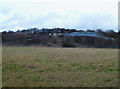
5
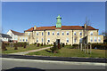
Block with clock tower, former Runwell Hospital
A surviving building at the mental hospital site, which has been redeveloped with a large housing estate, Runwell Park.
Image: © Robin Webster
Taken: 5 Feb 2023
0.18 miles
6
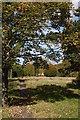
Unused path
Taken through the security fence which surrounds the site of what was Runwell Hospital. A view along a disused path through the grounds of the very large former mental hospital, now mainly demolished.
Image: © Trevor Harris
Taken: 20 Oct 2014
0.20 miles
7
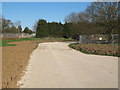
Construction site, former Runwell Hospital
Planning permission has been granted to develop a new residential area on parts of the former Runwell Hospital Site. Here you can see a new road surface which has been recently laid.
see also: Image]
Image: © Roger Jones
Taken: 18 Apr 2015
0.25 miles