IMAGES TAKEN NEAR TO
Keel Close, SALISBURY, SP5 1BF
Introduction
This page details the photographs taken nearby to Keel Close, SP5 1BF by members of the Geograph project.
The Geograph project started in 2005 with the aim of publishing, organising and preserving representative images for every square kilometre of Great Britain, Ireland and the Isle of Man.

There are currently over 7.5m images from over14,400 individuals and you can help contribute to the project by visiting https://www.geograph.org.uk
Image Map
Images are licensed for reuse under creativecommons.org/licenses/by-sa/2.0
Notes
- Clicking on the map will re-center to the selected point.
- The higher the marker number, the further away the image location is from the centre of the postcode.
Image Listing (23 Images Found)
Images are licensed for reuse under creativecommons.org/licenses/by-sa/2.0
Image
Details
Distance
1
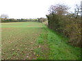
Middle Winterslow, footpath
Along a field margin towards Hill Farm.
Image: © Mike Faherty
Taken: 7 Dec 2013
0.03 miles
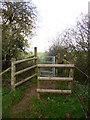
2
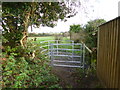
Middle Winterslow, kissing gate
One of several sets of gates in the parish, modern and efficient; on the path towards Hill Farm.
Image: © Mike Faherty
Taken: 7 Dec 2013
0.04 miles
3

Roman road through Middle Winterslow
The status of the road changes a few times, but the route through the village is clearly a Roman one, when you know. This is the route from Winchester (Venta) to Old Sarum (Sorviodvnvm) and is traceable virtually throughout.
The bus stop is more recent, and marks the edge of the square.
Image: © Graham Horn
Taken: 16 Aug 2008
0.06 miles
4
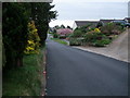
Middleton Road, Middle Winterslow
Along the line of a Roman Road, and the route of the Clarendon Way
Image: © Tim Heaton
Taken: 9 May 2010
0.07 miles
5
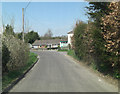
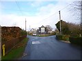
Middleton Road junction with The Causeway
Joining from the right is a Roman Road (The Causeway) linking Winchester (Venta) to Old Sarum (Sorviodvnvm).
Image: © Stuart Logan
Taken: 25 Apr 2013
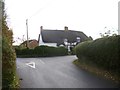
0.08 miles
6
Middle Winterslow, gate
Across a field margin, on the path to East Winterslow.
Image: © Mike Faherty
Taken: 7 Dec 2013
0.08 miles
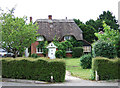
7
Middle Winterslow, Tudor Cottage
Thatched, half-timbered cottages at the corner of Middleton and Middleton Road; listed by English Heritage: http://www.imagesofengland.org.uk/Details/Default.aspx?id=320106&mode=adv
Image: © Mike Faherty
Taken: 7 Dec 2013
0.09 miles
8
The Causeway, Middle Winterslow
This is part of a Roman Road, now adopted by the Clarendon Way - they have one thing in common, as they both link Salisbury to Winchester.
Image: © Chris Heaton
Taken: 9 May 2010
0.11 miles
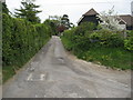
10
Middle Winterslow, road junction
Left, The Flood, towards The Pheasant; right, Middleton, to Roman Road.
Image: © Mike Faherty
Taken: 7 Dec 2013
0.13 miles