IMAGES TAKEN NEAR TO
Court Street, SALISBURY, SP3 6LS
Introduction
This page details the photographs taken nearby to Court Street, SP3 6LS by members of the Geograph project.
The Geograph project started in 2005 with the aim of publishing, organising and preserving representative images for every square kilometre of Great Britain, Ireland and the Isle of Man.

There are currently over 7.5m images from over14,400 individuals and you can help contribute to the project by visiting https://www.geograph.org.uk
Image Map (Loading...)


Getting Data...Please wait
Leaflet Map data © OpenStreetMap
Images are licensed for reuse under creativecommons.org/licenses/by-sa/2.0
Notes
- Clicking on the map will re-center to the selected point.
- The higher the marker number, the further away the image location is from the centre of the postcode.
Image Listing (48 Images Found)
Images are licensed for reuse under creativecommons.org/licenses/by-sa/2.0
Image
Details
Distance
2
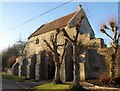
Gatehouse. Tisbury
The C15 outer gatehouse at Place Farm is also shown in http://www.geograph.org.uk/search.php?i=18443282 . "Fine surviving example of entrance to monastic grange of the Abbess of Shaftesbury" http://www.britishlistedbuildings.co.uk/en-321000-outer-gatehouse-at-place-farm-tisbury .
Image: © Derek Harper
Taken: 9 Jan 2011
0.06 miles
4
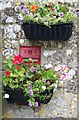
Victorian Postbox, Tisbury
This dis-used postbox has become a garden feature.
Image: © Maigheach-gheal
Taken: 10 Aug 2008
0.06 miles
5
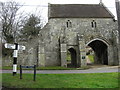
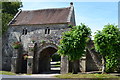
Imposing outer entrance to Place Farm
The grange, or administrative headquarters, of the Tisbury estate was at Place Farm. The outer gatehouse, the abbess’s house of the early 14th century and the inner gatehouse and barn of the 15th century survive in remarkably good order.
Image: © David Redwood
Taken: 22 Feb 2012
0.07 miles
6
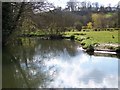
River Nadder, Tisbury Mill
Looking upstream. A good place to see Kingfishers.
Image: © Maigheach-gheal
Taken: 27 Mar 2008
0.08 miles
7
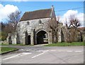
Gatehouse to Place Farm
Place Farm was originally a grange owned by the abbesses of Shaftesbury. The gatehouse, farmhouse and tithe barn form a fine example of a medieval farm grouping.
Image: © Maigheach-gheal
Taken: 27 Mar 2008
0.08 miles
8
River Nadder, Tisbury
The River Nadder (downstream) near Tisbury Mill.
Image: © Maigheach-gheal
Taken: 27 Mar 2008
0.09 miles
9
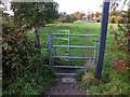
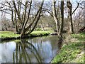
Kissing gate
The gate allows access to the footpath that leads from Court Street to The Avenue, the trees on the left line the bank of the River Nadder.
Image: © Jonathan Kington
Taken: 29 Oct 2011
0.09 miles
10
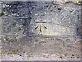
Bench Mark, Tisbury
The bench mark is to be found on the face of Court Street Bridge. Image and http://www.bench-marks.org.uk/bm33547
A bench mark is an Ordnance Survey arrowhead sign found on walls, bridges, churches and specially erected concrete posts where the altitude above sea-level has been accurately measured by surveyors. The arrowhead points to a horizontal line above it which marks the exact altitude.
Image: © Maigheach-gheal
Taken: 17 Mar 2010
0.09 miles