IMAGES TAKEN NEAR TO
Priory Close, SALISBURY, SP3 4LE
Introduction
This page details the photographs taken nearby to Priory Close, SP3 4LE by members of the Geograph project.
The Geograph project started in 2005 with the aim of publishing, organising and preserving representative images for every square kilometre of Great Britain, Ireland and the Isle of Man.

There are currently over 7.5m images from over14,400 individuals and you can help contribute to the project by visiting https://www.geograph.org.uk
Image Map
Images are licensed for reuse under creativecommons.org/licenses/by-sa/2.0
Notes
- Clicking on the map will re-center to the selected point.
- The higher the marker number, the further away the image location is from the centre of the postcode.
Image Listing (100 Images Found)
Images are licensed for reuse under creativecommons.org/licenses/by-sa/2.0
Image
Details
Distance
1
![Shrewton features [2]](https://s3.geograph.org.uk/geophotos/06/39/96/6399615_26af3e7f_120x120.jpg)
Shrewton features [2]
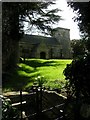
The wall on the right of this un-named track runs around some 20th century housing in Abbey Close, Priory Close and Manor Close. Built circa 1600, and probably the close walls of the Grange at Maddington, formerly of the Benedictine nunnery at Amesbury. Listed, grade II, with details at: https://historicengland.org.uk/listing/the-list/list-entry/1355686
The village of Shrewton is located on Salisbury Plain and is made up of several early communities and was, until 1934 three separate parishes. The name Shrewton comes from the Old English word for sheriff’s farm or settlement. The village lies on the east to west road from London to Bridgwater via Amesbury and Warminster. The River Till which rises near Tilshead flows through the village on its way to join the River Wylye near Stapleford.
Image: © Michael Dibb
Taken: 29 Jan 2020
0.02 miles
2
![Former parish church [6]](https://s3.geograph.org.uk/geophotos/06/39/90/6399095_612a225b_120x120.jpg)
Former parish church [6]
The organ.
The former Anglican parish church for the parish of Maddington, St Mary's, has parts from the 13th, 14th and 15th centuries but was mostly rebuilt in 1637. There were two restorations in the 1840s. The church ceased to be used in 1976 and is now maintained by the Churches Conservation Trust. Listed, grade II*, with details at: https://historicengland.org.uk/listing/the-list/list-entry/1023959
The village of Shrewton is located on Salisbury Plain and is made up of several early communities and was, until 1934 three separate parishes. The name Shrewton comes from the Old English word for sheriff’s farm or settlement. The village lies on the east to west road from London to Bridgwater via Amesbury and Warminster. The River Till which rises near Tilshead flows through the village on its way to join the River Wylye near Stapleford.
Image: © Michael Dibb
Taken: 29 Jan 2020
0.05 miles
3
![Former parish church [5]](https://s3.geograph.org.uk/geophotos/06/39/90/6399083_4c26699a_120x120.jpg)
Former parish church [5]
The font is dated 1846.
The former Anglican parish church for the parish of Maddington, St Mary's, has parts from the 13th, 14th and 15th centuries but was mostly rebuilt in 1637. There were two restorations in the 1840s. The church ceased to be used in 1976 and is now maintained by the Churches Conservation Trust. Listed, grade II*, with details at: https://historicengland.org.uk/listing/the-list/list-entry/1023959
The village of Shrewton is located on Salisbury Plain and is made up of several early communities and was, until 1934 three separate parishes. The name Shrewton comes from the Old English word for sheriff’s farm or settlement. The village lies on the east to west road from London to Bridgwater via Amesbury and Warminster. The River Till which rises near Tilshead flows through the village on its way to join the River Wylye near Stapleford.
Image: © Michael Dibb
Taken: 29 Jan 2020
0.05 miles
4
![Former parish church [4]](https://s3.geograph.org.uk/geophotos/06/39/90/6399079_a87e728e_120x120.jpg)
Former parish church [4]
The tower arch with strapwork and the date of the major rebuild - 1637.
The former Anglican parish church for the parish of Maddington, St Mary's, has parts from the 13th, 14th and 15th centuries but was mostly rebuilt in 1637. There were two restorations in the 1840s. The church ceased to be used in 1976 and is now maintained by the Churches Conservation Trust. Listed, grade II*, with details at: https://historicengland.org.uk/listing/the-list/list-entry/1023959
The village of Shrewton is located on Salisbury Plain and is made up of several early communities and was, until 1934 three separate parishes. The name Shrewton comes from the Old English word for sheriff’s farm or settlement. The village lies on the east to west road from London to Bridgwater via Amesbury and Warminster. The River Till which rises near Tilshead flows through the village on its way to join the River Wylye near Stapleford.
Image: © Michael Dibb
Taken: 29 Jan 2020
0.05 miles
5
Maddington, St Mary, Wiltshire
See discussion in Image
Image: © ChurchCrawler
Taken: 1 Apr 2006
0.05 miles
6
![Shrewton features [1]](https://s3.geograph.org.uk/geophotos/06/39/88/6398803_b4222f2a_120x120.jpg)
Shrewton features [1]
This wall is enclosing the approach path to the church of St Mary. Part of the wall is 17th century extended in the late 18th or early 19th century. Listed, grade II, with details at: https://historicengland.org.uk/listing/the-list/list-entry/1253554
The village of Shrewton is located on Salisbury Plain and is made up of several early communities and was, until 1934 three separate parishes. The name Shrewton comes from the Old English word for sheriff’s farm or settlement. The village lies on the east to west road from London to Bridgwater via Amesbury and Warminster. The River Till which rises near Tilshead flows through the village on its way to join the River Wylye near Stapleford.
Image: © Michael Dibb
Taken: 29 Jan 2020
0.05 miles
7
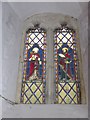
St Mary, Maddington: stained glass window (I)
Image: © Basher Eyre
Taken: 19 Aug 2016
0.06 miles
8

St Mary, Maddington: stained glass window (II)
Image: © Basher Eyre
Taken: 19 Aug 2016
0.06 miles
10
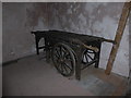
Inside St Mary, Maddington (4)
A funeral cart
Image: © Basher Eyre
Taken: 19 Aug 2016
0.06 miles