IMAGES TAKEN NEAR TO
Oak Ash Green, SALISBURY, SP2 0RR
Introduction
This page details the photographs taken nearby to Oak Ash Green, SP2 0RR by members of the Geograph project.
The Geograph project started in 2005 with the aim of publishing, organising and preserving representative images for every square kilometre of Great Britain, Ireland and the Isle of Man.

There are currently over 7.5m images from over14,400 individuals and you can help contribute to the project by visiting https://www.geograph.org.uk
Image Map (Loading...)


Getting Data...Please wait
Leaflet Map data © OpenStreetMap
Images are licensed for reuse under creativecommons.org/licenses/by-sa/2.0
Notes
- Clicking on the map will re-center to the selected point.
- The higher the marker number, the further away the image location is from the centre of the postcode.
Image Listing (22 Images Found)
Images are licensed for reuse under creativecommons.org/licenses/by-sa/2.0
Image
Details
Distance
1
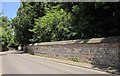
Wilton Park wall
Seen on South Street opposite the junction with Bulbridge Road. The wall i listed http://www.britishlistedbuildings.co.uk/en-319343-park-walls-to-south-and-west-south-of-ri . "Ordered by 9th Earl of Pembroke to be built "after
the Roman fashion" of large rubble blocks with wide brick bands and weathered
stone capping."
Image: © Derek Harper
Taken: 19 Jun 2014
0.08 miles
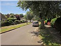
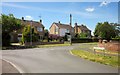
2
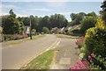
Bulbridge Road
The residential road passes the end of Chantry Road on the right Image] and approaches the T junction with South Street.
Image: © Derek Harper
Taken: 19 Jun 2014
0.09 miles
4
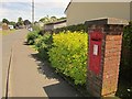
Postbox, Bulbridge
Elizabeth II postbox SP2 190 is on Seagrim Road near its junction with Bulbridge Road.
Image: © Derek Harper
Taken: 19 Jun 2014
0.10 miles
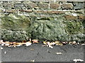
5
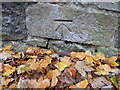
Bench Mark, South Street
The Ordnance Survey cut mark is to be found on the wall in Image and for further information on the mark and others in the area http://www.bench-marks.org.uk/bm40312
Image: © Maigheach-gheal
Taken: 21 Nov 2011
0.11 miles
6
Park Wall, South Street
The wall is part of the boundary wall around the Pembroke Estate.
Image: © Maigheach-gheal
Taken: 21 Nov 2011
0.11 miles
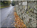
7
Park Wall, Bulbridge
The wall is the western boundary to Wilton Park. There is an Ordnance Survey bench mark just to the left of the 30mph sign.
Image: © Maigheach-gheal
Taken: 3 Dec 2011
0.11 miles
8
Chantry Road, Bulbridge
From its junction with Bulbridge Road, shown in Image
Image: © Derek Harper
Taken: 19 Jun 2014
0.11 miles
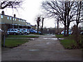
9
Junction in Bulbridge
From the same spot as Image], looking in the opposite direction.
Image: © Derek Harper
Taken: 19 Jun 2014
0.11 miles
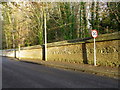
10
Bench Mark, Park Wall, Bulbridge
The Ordnance Survey bench mark is on the wall of the boundary to Wilton Park, home of the Earl and Countess of Pembroke. For a view of the wall Image and for further information on the cut mark http://www.bench-marks.org.uk/bm40428
Image: © Maigheach-gheal
Taken: 3 Dec 2011
0.12 miles