IMAGES TAKEN NEAR TO
Wiley Terrace, SALISBURY, SP2 0HN
Introduction
This page details the photographs taken nearby to Wiley Terrace, SP2 0HN by members of the Geograph project.
The Geograph project started in 2005 with the aim of publishing, organising and preserving representative images for every square kilometre of Great Britain, Ireland and the Isle of Man.

There are currently over 7.5m images from over14,400 individuals and you can help contribute to the project by visiting https://www.geograph.org.uk
Image Map
Images are licensed for reuse under creativecommons.org/licenses/by-sa/2.0
Notes
- Clicking on the map will re-center to the selected point.
- The higher the marker number, the further away the image location is from the centre of the postcode.
Image Listing (413 Images Found)
Images are licensed for reuse under creativecommons.org/licenses/by-sa/2.0
Image
Details
Distance
1
![Wilton features [5]](https://s3.geograph.org.uk/geophotos/07/04/38/7043807_35c24ef1_120x120.jpg)
Wilton features [5]
One of the strands of the River Wylye, looking upstream from one of the bridges carrying North Street.
A former county town, Wilton is situated some 2¾ miles west of Salisbury on the confluence of the River Nadder and the River Wylye. The town grew around Wilton Abbey, founded in the 8th century, and was the administrative capital of Wiltshire until the 11th century. The town declined in importance after Salisbury Cathedral was built. The town is renowned for carpet manufacture, which began in 1741 when two French weavers were brought in and a carpet factory continued to operate until 1995. The country estate of Wilton House is an integral part of the town.
Image: © Michael Dibb
Taken: 25 Aug 2021
0.04 miles
2
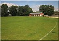
New pavilion, Castle Meadow, Wilton
The brick pavilion, opened in July 2012, is to the north of the former wooden pavilion which has been demolished.
Image: © Derek Harper
Taken: 19 Jun 2014
0.04 miles
3
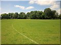
Castle Meadow, Wilton
This playing field has been levelled and re-seeded in recent years. The trees are along a channel of the River Wylye.
Image: © Derek Harper
Taken: 19 Jun 2014
0.04 miles
4
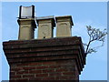
Chimney pots, North Street
The plant is alive even in this lofty and unfriendly place.
Image: © Maigheach-gheal
Taken: 20 Oct 2011
0.05 miles
5
![Wilton houses [8]](https://s2.geograph.org.uk/geophotos/07/04/38/7043810_ab9dba16_120x120.jpg)
Wilton houses [8]
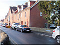
Odd numbers 67 to 75 North Street are a row of five cottages, with numbers 73 and 75 a different build. Number 67 has a late 19th century shopfront. Constructed of painted brick under a tile roof. Listed, grade II, with details at: https://historicengland.org.uk/listing/the-list/list-entry/1023725
A former county town, Wilton is situated some 2¾ miles west of Salisbury on the confluence of the River Nadder and the River Wylye. The town grew around Wilton Abbey, founded in the 8th century, and was the administrative capital of Wiltshire until the 11th century. The town declined in importance after Salisbury Cathedral was built. The town is renowned for carpet manufacture, which began in 1741 when two French weavers were brought in and a carpet factory continued to operate until 1995. The country estate of Wilton House is an integral part of the town.
Image: © Michael Dibb
Taken: 25 Aug 2021
0.05 miles
6
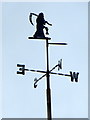
Weathervane, North Street
Weather vanes, which adorn many public buildings as well as private homes, are one of the oldest methods of weather prediction. Located on the highest point of tall structures and homes, they are a simple device balanced on a rotating axis, designed to indicate the direction of the wind. Weather vanes have a rich and long history, with examples dating to ancient Greece and Rome.
Image: © Maigheach-gheal
Taken: 20 Oct 2011
0.06 miles
7
![Wilton features [3]](https://s3.geograph.org.uk/geophotos/07/04/37/7043775_29ae4f7d_120x120.jpg)
Wilton features [3]
One of the strands of the River Wylye, looking upstream from Burden's Ball Bridge Image
A former county town, Wilton is situated some 2¾ miles west of Salisbury on the confluence of the River Nadder and the River Wylye. The town grew around Wilton Abbey, founded in the 8th century, and was the administrative capital of Wiltshire until the 11th century. The town declined in importance after Salisbury Cathedral was built. The town is renowned for carpet manufacture, which began in 1741 when two French weavers were brought in and a carpet factory continued to operate until 1995. The country estate of Wilton House is an integral part of the town.
Image: © Michael Dibb
Taken: 25 Aug 2021
0.06 miles
8
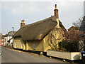
Wilton - Thatched House
On historic North Street; perhaps an 18th century building.
Image: © Colin Smith
Taken: 25 Mar 2022
0.07 miles
9
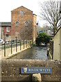
Wilton - River Wylye
View along this chalk stream from a bridge on North Street towards the old Wilton carpet factory complex.
Image: © Colin Smith
Taken: 25 Mar 2022
0.07 miles
10
Burden's Ball Bridge
Looking along North Street over the River Wylye on Burden's Ball Bridge. The Grade II Listed bridge ( http://www.britishlistedbuildings.co.uk/en-319268-burden-s-ball-bridge-wilton ) was originally built in the late 18th or early 19th century and was then first widened at the end of the 19th century with replacements done in the 1960's and again in 2010 ( http://www.wiltshire.gov.uk/parkingtransportandstreets/roadshighwayspavements/bridges/bridgescurrentlyunderconstruction/structuresscrossandburdensballbridge.htm ). There is a benchmark on the outside of the further buttress (Image).
Image: © Jonathan Kington
Taken: 5 Dec 2011
0.07 miles