IMAGES TAKEN NEAR TO
Sir Galahad Road, EASTLEIGH, SO53 4HH
Introduction
This page details the photographs taken nearby to Sir Galahad Road, SO53 4HH by members of the Geograph project.
The Geograph project started in 2005 with the aim of publishing, organising and preserving representative images for every square kilometre of Great Britain, Ireland and the Isle of Man.

There are currently over 7.5m images from over14,400 individuals and you can help contribute to the project by visiting https://www.geograph.org.uk
Image Map
Images are licensed for reuse under creativecommons.org/licenses/by-sa/2.0
Notes
- Clicking on the map will re-center to the selected point.
- The higher the marker number, the further away the image location is from the centre of the postcode.
Image Listing (22 Images Found)
Images are licensed for reuse under creativecommons.org/licenses/by-sa/2.0
Image
Details
Distance
1
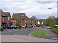
Harvest Road, Chandlers Ford
A typical street in this late 1990s development on the western edge of Chandlers Ford.
Image: © David Martin
Taken: 30 Apr 2010
0.04 miles
2
Crusaders Way, Chandler's Ford
With Zionshill Copse on the left / south side and a 1990s housing estate on the right / north side.
Image: © Christine Johnstone
Taken: 8 Nov 2021
0.05 miles
3
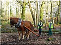
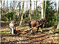
Valley Park - Logging the Old Fashion Way
Here is Titan working with a device called an Archer, which lifts the front end of the log lessening the drag.
See also Image
Image: © Chris Talbot
Taken: 2 Feb 2008
0.06 miles
4
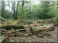
Logs and fungi, Zionshill Copse
Part of Valley Park local nature reserve, on the western edge of Chandler's Ford.
Image: © Christine Johnstone
Taken: 8 Nov 2021
0.06 miles
5
Valley Park - Logging the Old Fashion Way
Kip is an Ardennes draught horse and works alongside Titan who is a Suffolk Punch.
See Image]
and Image]
Image: © Chris Talbot
Taken: 4 Feb 2008
0.11 miles
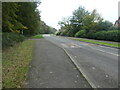
6
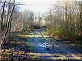
Valley Park - Logging Road
The recent rain has caused the surface to rut.
Image: © Chris Talbot
Taken: 4 Feb 2008
0.12 miles
7
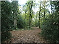
Path through Zionshill Copse
The copse is part of Valley Park local nature reserve, on the western edge of Chandler's Ford.
Image: © Christine Johnstone
Taken: 8 Nov 2021
0.12 miles
8
Houses on the north side of Harvest Road
Part of a large housing development on the western edge of Chandler's Ford.
Image: © Christine Johnstone
Taken: 8 Nov 2021
0.12 miles
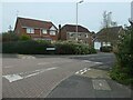
9
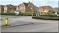
Roundabout and houses north of Zionshill Copse
This area was developed in the late 1990s.
Image: © David Martin
Taken: 4 Mar 2024
0.13 miles
10
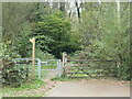
An entrance to Zionshill Copse
On the west side of Sky's Wood Road. The copse is part of Valley Park local nature reserve, on the western edge of Chandler's Ford.
Image: © Christine Johnstone
Taken: 8 Nov 2021
0.16 miles