IMAGES TAKEN NEAR TO
SO19 9YJ
Introduction
This page details the photographs taken nearby to SO19 9YJ by members of the Geograph project.
The Geograph project started in 2005 with the aim of publishing, organising and preserving representative images for every square kilometre of Great Britain, Ireland and the Isle of Man.

There are currently over 7.5m images from over14,400 individuals and you can help contribute to the project by visiting https://www.geograph.org.uk
Image Map
Images are licensed for reuse under creativecommons.org/licenses/by-sa/2.0
Notes
- Clicking on the map will re-center to the selected point.
- The higher the marker number, the further away the image location is from the centre of the postcode.
Image Listing (88 Images Found)
Images are licensed for reuse under creativecommons.org/licenses/by-sa/2.0
Image
Details
Distance
1
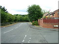
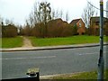
Victoria Road from the junction with Dundonald Close
Victoria Road from near its junction with Dundonald Close. A far less interesting view than the opposite direction, which overlooks Southampton Water and Ocean Dock, at which cruise liners call almost daily at certain times of the year.
Image: © Rob Candlish
Taken: 1 Aug 2010
0.01 miles
2
Victoria Road from the junction with Dundonald Close
Victoria Road from near the junction with Dundonald Close. Southampton Water is in the background with, on this occasion, Queen Mary 2 berthed in Ocean Dock beyond and being replenished ready for a 16:30 cruise departure. It had arrived at 06:30 the same morning off another cruise.
Image: © Rob Candlish
Taken: 1 Aug 2010
0.01 miles
3
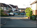
Dundonald Close, Woolston
A view of Dundonald Close, Woolston from its junction with Victoria Road. The masts of sailing boats in the nearby boatyard can be seen poking up above the houses on the right hand side in the background.
Image: © Rob Candlish
Taken: 28 Jul 2010
0.02 miles
4
Woolston Sailing club
A small storage area for boats at the mouth of the Itchen.
Image: © Hugh Venables
Taken: 3 Mar 2007
0.04 miles
5
Itchen Way (9)
This is the way to cross Victoria Road and head for the shore.
Image: © Shazz
Taken: 1 Mar 2013
0.04 miles
6
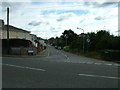
Swift Road, Woolston
Looking along Swift Road, Woolston from its junction with Victoria Road. The entrance to Woolston sewage works is immediately behind the camera.
Image: © Rob Candlish
Taken: 29 Jul 2010
0.05 miles
7
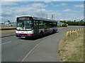
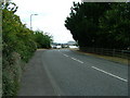
Victoria Road, Woolston
First Group 66128(S118JTP), a Wrights bodied Volvo B10BLE, approaching the sharp left hand bend in Victoria Road, Woolston outside Southampton Sailing Club on route 1A to Weston. In the background is the mobile telephone mast inside Woolston sewage works. Behind the yellow railings to the right is a public car park.
Image: © Rob Candlish
Taken: 5 Aug 2010
0.06 miles
8
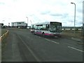
Victoria Road, Woolston and Southampton Water
66127 (S117JTP) a Wrights bodied Volvo B10BLE on First Group’s route 1A to Southampton city centre passing Southampton Sailing Club in Victoria Road, Woolston with Weston Point Jetty and Southampton Water in the right hand background.
Image: © Rob Candlish
Taken: 7 Aug 2010
0.07 miles
9
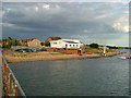
Southampton Sailing Club, Victoria Road, Woolston
Southampton Sailing Club viewed from Weston Point Jetty. The houses in the background are in Dundonald Close.
Image: © Rob Candlish
Taken: 5 Aug 2010
0.07 miles
10
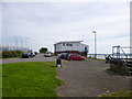
Southampton Sailing Club
On Victoria Road, Woolston. http://www.southamptonsailingclub.com/
Image: © Mike Faherty
Taken: 11 Aug 2012
0.07 miles