IMAGES TAKEN NEAR TO
Dimond Road, SOUTHAMPTON, SO18 1JX
Introduction
This page details the photographs taken nearby to Dimond Road, SO18 1JX by members of the Geograph project.
The Geograph project started in 2005 with the aim of publishing, organising and preserving representative images for every square kilometre of Great Britain, Ireland and the Isle of Man.

There are currently over 7.5m images from over14,400 individuals and you can help contribute to the project by visiting https://www.geograph.org.uk
Image Map (Loading...)


Getting Data...Please wait
Leaflet Map data © OpenStreetMap
Images are licensed for reuse under creativecommons.org/licenses/by-sa/2.0
Notes
- Clicking on the map will re-center to the selected point.
- The higher the marker number, the further away the image location is from the centre of the postcode.
Image Listing (14 Images Found)
Images are licensed for reuse under creativecommons.org/licenses/by-sa/2.0
Image
Details
Distance
1

Bitterne Park School
A secondary school on an extensive site between Dimond and Copsewood Roads: https://en.wikipedia.org/wiki/Bitterne_Park_School (the school website appears to be currently down).
Image: © Mike Faherty
Taken: 31 Dec 2016
0.11 miles
2
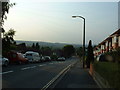
Woodmill Lane, Southampton
Looking North along Woodmill Lane, Townhill Park.
Image: © GaryReggae
Taken: 13 Jul 2005
0.13 miles
3
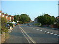
Woodmill Lane, Southampton
Woodmill Lane, looking South up the hill towards The Castle pub.
Image: © GaryReggae
Taken: 13 Jul 2005
0.13 miles
4
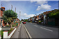
Oak Tree Road
A residential road in Bitterne Park. The trees almost make it look tropical.
Image: © Bill Boaden
Taken: 29 Sep 2016
0.18 miles
6
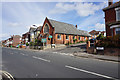
Bitterne Park Baptist Church
Situated in the middle of a large residential area.
Image: © Bill Boaden
Taken: 29 Sep 2016
0.21 miles
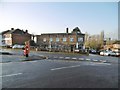
7
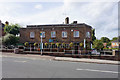
The Hop Inn
A pub at the northern end of Bitterne Park with a few good local beers.
Image: © Bill Boaden
Taken: 29 Sep 2016
0.22 miles
9
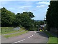
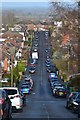
View down Dell Road
The road descends very steeply here from its junction with Castle Road and Midanbury Lane. In the far distance, the runway of Southampton Airport is visible - at a much lower elevation than the photographer.
Image: © David Martin
Taken: 10 Aug 2011
0.23 miles
10
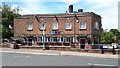
Bitterne Park, Hop Inn
Cosy, Good Beer Guide-listed pub on Oak Tree Road. Internally, traditional two-room layout, with public bar and lounge, and central horseshoe-shaped counter. Cask ales on offer at my visit: Bowman, Swift One; Flack's Double; Gale HSB; Greene King Abbot; Sharp's Doom Bar.
Image: © Mike Faherty
Taken: 31 Dec 2016
0.23 miles