IMAGES TAKEN NEAR TO
Test Lane, SOUTHAMPTON, SO16 9BH
Introduction
This page details the photographs taken nearby to Test Lane, SO16 9BH by members of the Geograph project.
The Geograph project started in 2005 with the aim of publishing, organising and preserving representative images for every square kilometre of Great Britain, Ireland and the Isle of Man.

There are currently over 7.5m images from over14,400 individuals and you can help contribute to the project by visiting https://www.geograph.org.uk
Image Map
Images are licensed for reuse under creativecommons.org/licenses/by-sa/2.0
Notes
- Clicking on the map will re-center to the selected point.
- The higher the marker number, the further away the image location is from the centre of the postcode.
Image Listing (90 Images Found)
Images are licensed for reuse under creativecommons.org/licenses/by-sa/2.0
Image
Details
Distance
1
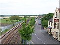
Road, rail and river at Redbridge
View north from the modern road bridge which crosses the old road, railway and River Test adjacent to the Anchor public house
Image: © David Martin
Taken: 20 May 2008
0.02 miles
2
River Test & Railway at Redbridge
Viewed from the original causeway bridge, a Salisbury bound train departs from Redbridge
Image: © John Lucas
Taken: 30 May 1985
0.03 miles
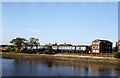
3
Looking across Red Bridge to The Anchor pub
It bridges the River Test.
Image: © Peter Facey
Taken: 28 Sep 2008
0.05 miles
4
Train at Redbridge
Viewed here from the old causeway bridge, a Cardiff bound train, hauled by a class 33 locomotive, emerges from beneath the A35 road bridge.
Image: © John Lucas
Taken: 30 May 1985
0.05 miles
5
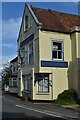
The Anchor public house, Redbridge
The pub appears to be permanently closed, judging by appearances and its Facebook page.
Image: © David Martin
Taken: 6 Oct 2023
0.05 miles
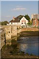
6
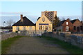
Red Bridge and The Anchor public house
The Southampton to Salisbury railway line crosses in front of the pub beyond the metal railing: there is no access to the eastern shore from the old bridge.
Image: © David Martin
Taken: 19 Nov 2017
0.06 miles
7
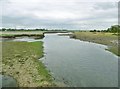
Totton, River Test
Looking upstream from Redbridge Causeway. The river here is tidal, and divides into two channels through reedbeds.
Image: © Mike Faherty
Taken: 1 Jul 2017
0.06 miles
8
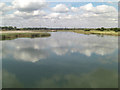
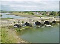
River Test at Redbridge
This is the lowest bridging point of the 40 mile long river. It starts just west of Basingstoke and for much of its length is a World renowned trout fishery. The trout thrive in its fast flowing chalky waters but down here, viewed from the 17th C disused Red Bridge, the tide is sweeping in.
Image: © Stuart Logan
Taken: 15 Sep 2011
0.07 miles
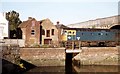
9
Totton, Redbridge Bridge
One of two historic roadbridges carrying the former Redbridge Causeway over River Test - this one, to the East, is C17 and listed by Historic England (Grade II*): http://www.imagesofengland.org.uk/Details/Default.aspx?id=143493&mode=adv
Image: © Mike Faherty
Taken: 1 Jul 2017
0.07 miles
10

Red Bridge, Redbridge
This bridge originally led to the Anchor pub, seen at right, but the road is now blocked off by the railway line. The modern road bridges are behind camera. For the other side of this bridge and its general situation, see Image
Image: © Peter Facey
Taken: 28 Sep 2008
0.07 miles