IMAGES TAKEN NEAR TO
Adanac Drive, SOUTHAMPTON, SO16 0BT
Introduction
This page details the photographs taken nearby to Adanac Drive, SO16 0BT by members of the Geograph project.
The Geograph project started in 2005 with the aim of publishing, organising and preserving representative images for every square kilometre of Great Britain, Ireland and the Isle of Man.

There are currently over 7.5m images from over14,400 individuals and you can help contribute to the project by visiting https://www.geograph.org.uk
Image Map
Images are licensed for reuse under creativecommons.org/licenses/by-sa/2.0
Notes
- Clicking on the map will re-center to the selected point.
- The higher the marker number, the further away the image location is from the centre of the postcode.
Image Listing (133 Images Found)
Images are licensed for reuse under creativecommons.org/licenses/by-sa/2.0
Image
Details
Distance
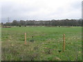
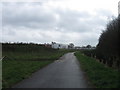
2
Field in Adanac Park
Adanac Park is a business park part of which had not been built at time of photographing. The path here is used by local people but does not appear to be a public right of way. Beyond is the new Ordnance Survey HQ, which was the only completed plot. For a view of that, taken from atop the spoil heap seen at right, see http://www.geograph.org.uk/photo/2295221 .
Image: © Peter Facey
Taken: 5 Mar 2011
0.08 miles
3

War memorial at the Ordnance Survey offices
'In memory of those members of Ordnance Survey who gave their lives in the World Wars'.
Image: © Rod Allday
Taken: 27 Jun 2014
0.09 miles
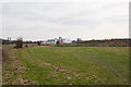
4
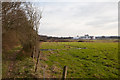
Path along western edge of Home Covert
This path is used by local people but is not a public footpath. For the building, see http://www.geograph.org.uk/photo/2295422 .
Image: © Peter Facey
Taken: 5 Mar 2011
0.09 miles
5

War memorial at Ordnance Survey Head Office
See http://www.geograph.org.uk/photo/1713778 from 2010. The answer to the question posed then is now known.
Image: © Shazz
Taken: 27 Jun 2014
0.09 miles
6

Plaque on war memorial at Ordnance Survey Head Office
For a view of the memorial see Image
Image: © Shazz
Taken: 27 Jun 2014
0.09 miles
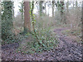
7
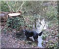
Felled Tree and little footpath bridge and stream Home Covert, Nursling
Many dogs on their daily walks through Home Coverts stop for a little Splash in the three streams between the mound and the path leading down to Adanac farm/ Park. This is the Second Bridge, just past the junction off to Nursling Street and the Four Horse Shoes.
Image: © J W Parker
Taken: 20 Jan 2011
0.10 miles
9
Triangular roundabout marks path to Four Horse shoes (Nursling Street) through Home Covert woods
When following the main Path from Nursling Recreation Ground down towards Hillyfields and Adanac Farm, you go up and down a little mound and over a little bridge, to get to this junction which diverts off to the right to go to Nursling Street and the Four Horse Shoes pub.
Image: © J W Parker
Taken: 20 Jan 2011
0.11 miles
