1
Farm road east of Bedwyn Common, near Great Bedwyn
The house on the right has uncommonly intricate windows. The track is unremarkable.
Image: © Brian Robert Marshall
Taken: 12 Apr 2007
0.05 miles
2
Moss, Bedwyn Common
Moss is a small green plant, rarely more than a few inches high, which grows anywhere not overshadowed by taller vegetation or perpetually dry. There are more than 600 species in the British Isles, growing on rocks and walls, in woodlands and on tree trunks and branches. They are important pioneers of rock surfaces, holding moisture in their leaves and building up humus in which the seeds of flowering plants can germinate.
There are two alternating generations in the life cycle of moss. The plant itself carries male and female organs. After fertilisation, these produce a capsule. Stalk and capsule together form an asexual, spore-bearing generation. The spores produced are capable of germinating into a new plant. Mosses also reproduce vegetatively, by small pieces breaking off and growing into a new plant.
As they are rootless and tend to get their nutrients from water running over or through them they are nearly always short.
Image: © Maigheach-gheal
Taken: 5 Mar 2011
0.11 miles
3
Footpath, Bedwyn Common
The footpath follows this wide ride through the wooded common.
Image: © Maigheach-gheal
Taken: 5 Mar 2011
0.12 miles
4
Chisbury Lane
Looking in the other direction along the lane from the spot where
Image] was taken, past a line of conifers to the junction near Buckwood. The lane here is followed by the parish boundary between Great (left) and Little Bedwyn.
Image: © Derek Harper
Taken: 21 Jun 2014
0.13 miles
5
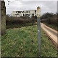
Direction Sign ? Signpost
Located on the northeast side of a T junction near Chisbury Lane Farm in Little Bedwyn parish. 1 arm and pyramid cap.
Milestone Society National ID: WI_SU2666
Image: © S Kosciow
Taken: 6 Jan 2019
0.14 miles
6
The road to Great Bedwyn, west of Chisbury
The bridleway at the left leads north-east to the A4 at Harrow Farm http://www.geograph.org.uk/photo/99649
Image: © Brian Robert Marshall
Taken: 8 Apr 2009
0.15 miles
7
Un-named lane west of Chisbury Lane Farm
Image: © Stuart Logan
Taken: 24 Jul 2012
0.17 miles
8
Chisbury Lane
With Chisbury Lane Farm on the left. The lane here is followed, as far as the left bend, by the parish boundary between Great (right) and Little Bedwyn.
Image: © Derek Harper
Taken: 21 Jun 2014
0.18 miles
9
Path into Bedwyn Common
Footpath GBED 19 leaves the road along this track into Bedwyn Common, an eastern offshoot of Savernake Forest.
Image: © Derek Harper
Taken: 21 Jun 2014
0.19 miles
10
Chisbury Lane Farm, west of Chisbury
The farm comprises a number of large buildings probably used in part for housing cattle.
Image: © Brian Robert Marshall
Taken: 8 Apr 2009
0.20 miles


