IMAGES TAKEN NEAR TO
Conifer Crest, MARLBOROUGH, SN8 3DT
Introduction
This page details the photographs taken nearby to Conifer Crest, SN8 3DT by members of the Geograph project.
The Geograph project started in 2005 with the aim of publishing, organising and preserving representative images for every square kilometre of Great Britain, Ireland and the Isle of Man.

There are currently over 7.5m images from over14,400 individuals and you can help contribute to the project by visiting https://www.geograph.org.uk
Image Map
Images are licensed for reuse under creativecommons.org/licenses/by-sa/2.0
Notes
- Clicking on the map will re-center to the selected point.
- The higher the marker number, the further away the image location is from the centre of the postcode.
Image Listing (81 Images Found)
Images are licensed for reuse under creativecommons.org/licenses/by-sa/2.0
Image
Details
Distance
1
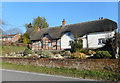
![Burbage buildings [5]](https://s2.geograph.org.uk/geophotos/07/39/59/7395998_3d12486c_120x120.jpg)
Burbage buildings [5]
Now a private house, number 141 High Street, this is the former Bullfinch public House, earlier The New Inn. Built in the 19th century of rendered brick under a tile roof.
Burbage is a village in the Vale of Pewsey, Wiltshire, it lies about 5½ miles southeast of Marlborough and some 15½ miles west of Newbury. The narrow village High Street was the main north to south road from Marlborough to Andover (A346) until a bypass was built to the west in 1991. Settlement can be traced back to the Neolithic period, and Bronze Age artefacts have been found. Burbage is now essentially a commuter village.
Image: © Michael Dibb
Taken: 23 Jan 2023
0.03 miles
2
Old Houses, Burbage High Street
The traditional old houses in Burbage village are now outnumbered by 20th and 21st century developments.
Image: © Des Blenkinsopp
Taken: 27 Feb 2019
0.03 miles
3
![Burbage houses [20]](https://s2.geograph.org.uk/geophotos/07/39/59/7395990_582a7157_120x120.jpg)
Burbage houses [20]
Conifer Cottage, number 135 High Street, was originally two cottages, now one house. Built in the late 16th century, altered in the early 17th century and extended in the 18th century. Timber framed with red brick nogging under a thatch roof. The first bay of the original build is on the left with framing 2 panels high heavy curved corner braces. The second bay has been altered to 3 panels high without braces. Listed, grade II, with details at: https://historicengland.org.uk/listing/the-list/list-entry/1194485
Burbage is a village in the Vale of Pewsey, Wiltshire, it lies about 5½ miles southeast of Marlborough and some 15½ miles west of Newbury. The narrow village High Street was the main north to south road from Marlborough to Andover (A346) until a bypass was built to the west in 1991. Settlement can be traced back to the Neolithic period, and Bronze Age artefacts have been found. Burbage is now essentially a commuter village.
Image: © Michael Dibb
Taken: 23 Jan 2023
0.03 miles
4
![Burbage ways [3]](https://s2.geograph.org.uk/geophotos/07/39/59/7395986_22a6f7e0_120x120.jpg)
Burbage ways [3]
The village has an extensive network of footpaths between High Street and Eastcote Road. This path, between numbers 131 and 135 High Street, leads into that network.
Burbage is a village in the Vale of Pewsey, Wiltshire, it lies about 5½ miles southeast of Marlborough and some 15½ miles west of Newbury. The narrow village High Street was the main north to south road from Marlborough to Andover (A346) until a bypass was built to the west in 1991. Settlement can be traced back to the Neolithic period, and Bronze Age artefacts have been found. Burbage is now essentially a commuter village.
Image: © Michael Dibb
Taken: 23 Jan 2023
0.04 miles
5
![Burbage houses [22]](https://s2.geograph.org.uk/geophotos/07/39/60/7396002_5095c9d7_120x120.jpg)
Burbage houses [22]
Hallams, number 166 High Street, was built in the late 16th or early 17th century. Timber framed with brick nogging under a thatch roof. Later, a crosswing on the right and a single bay on the left were added in brick. Listed, grade II, with details at: https://historicengland.org.uk/listing/the-list/list-entry/1035924
Burbage is a village in the Vale of Pewsey, Wiltshire, it lies about 5½ miles southeast of Marlborough and some 15½ miles west of Newbury. The narrow village High Street was the main north to south road from Marlborough to Andover (A346) until a bypass was built to the west in 1991. Settlement can be traced back to the Neolithic period, and Bronze Age artefacts have been found. Burbage is now essentially a commuter village.
Image: © Michael Dibb
Taken: 23 Jan 2023
0.04 miles
6
![Burbage houses [19]](https://s0.geograph.org.uk/geophotos/07/39/59/7395984_0e8380fc_120x120.jpg)
Burbage houses [19]
Hargay Cottage, number 129 High Street, was built in the 17th century. Timber framed with brick nogging under a thatch roof. The font and sides are rendered. The framing is 2 panels high with straight corner braces. Some original internal features remain. Listed, grade II, with details at: https://historicengland.org.uk/listing/the-list/list-entry/1035917
Burbage is a village in the Vale of Pewsey, Wiltshire, it lies about 5½ miles southeast of Marlborough and some 15½ miles west of Newbury. The narrow village High Street was the main north to south road from Marlborough to Andover (A346) until a bypass was built to the west in 1991. Settlement can be traced back to the Neolithic period, and Bronze Age artefacts have been found. Burbage is now essentially a commuter village.
Image: © Michael Dibb
Taken: 23 Jan 2023
0.07 miles
7
![Burbage ways [4]](https://s3.geograph.org.uk/geophotos/07/39/59/7395999_425bdeb1_120x120.jpg)
Burbage ways [4]
The village has an extensive network of footpaths between High Street and Eastcote Road. This path, between numbers 151 and 157 High Street, leads into that network.
Burbage is a village in the Vale of Pewsey, Wiltshire, it lies about 5½ miles southeast of Marlborough and some 15½ miles west of Newbury. The narrow village High Street was the main north to south road from Marlborough to Andover (A346) until a bypass was built to the west in 1991. Settlement can be traced back to the Neolithic period, and Bronze Age artefacts have been found. Burbage is now essentially a commuter village.
Image: © Michael Dibb
Taken: 23 Jan 2023
0.08 miles
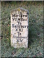
9
Old Milestone by High Street, Burbage
Carved stone post by the UC road (was A346), in parish of BURBAGE (KENNET District), High Street, by No. 129, opposite Burbage Post Office, in well cut grass bank below high domestic hedge, on West side of road. Marlborough gable, erected by the Marlborough & Salisbury turnpike trust in the 18th century.
Inscription reads:-
To
Marlbro
VI Miles
To Salisbury
XXI
To Andover
XV
Grade II Listed. List Entry Number: 1364602
https://historicengland.org.uk/listing/the-list/list-entry/1364602
Milestone Society National ID: WI_MLSA06.
Image: © A Rosevear
Taken: 23 Mar 2003
0.10 miles
10
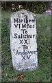
![Burbage features [3]](https://s3.geograph.org.uk/geophotos/07/39/60/7396007_d43d5c4b_120x120.jpg)
Burbage features [3]
In front of number 192 High Street stands this 18th century milestone. A rectangular pillar with gabled top. The painted inscription read To Marlbro VI Miles; To Salisbury XXI; To Andover XV: There is a closer view of the milestone at Image Listed, grade II, with details at: https://historicengland.org.uk/listing/the-list/list-entry/1364602
Burbage is a village in the Vale of Pewsey, Wiltshire, it lies about 5½ miles southeast of Marlborough and some 15½ miles west of Newbury. The narrow village High Street was the main north to south road from Marlborough to Andover (A346) until a bypass was built to the west in 1991. Settlement can be traced back to the Neolithic period, and Bronze Age artefacts have been found. Burbage is now essentially a commuter village.
Image: © Michael Dibb
Taken: 23 Jan 2023
0.10 miles