IMAGES TAKEN NEAR TO
High Street, MARLBOROUGH, SN8 2QP
Introduction
This page details the photographs taken nearby to High Street, SN8 2QP by members of the Geograph project.
The Geograph project started in 2005 with the aim of publishing, organising and preserving representative images for every square kilometre of Great Britain, Ireland and the Isle of Man.

There are currently over 7.5m images from over14,400 individuals and you can help contribute to the project by visiting https://www.geograph.org.uk
Image Map (Loading...)


Getting Data...Please wait
Leaflet Map data © OpenStreetMap
Images are licensed for reuse under creativecommons.org/licenses/by-sa/2.0
Notes
- Clicking on the map will re-center to the selected point.
- The higher the marker number, the further away the image location is from the centre of the postcode.
Image Listing (248 Images Found)
Images are licensed for reuse under creativecommons.org/licenses/by-sa/2.0
Image
Details
Distance
1
![Ramsbury houses [15]](https://s2.geograph.org.uk/geophotos/06/44/62/6446246_d908766c_120x120.jpg)
Ramsbury houses [15]
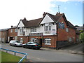
York House, number 38 High Street is a large terraced property. The building was formerly The Burdett Arms public house (earlier named The White House) which closed in 2009. Now a private dwelling.
Ramsbury lies in fertile farming land in the valley of the River Kennet. The site has been occupied since at least the Iron Age and there are several Roman villas. There was a bishopric of Ramsbury, established by 909 and ended in 1075 when it was included in the bishopric of Salisbury. Until 1744 when the present A4 road was turnpiked, the road through the village was part of the main route from London to Bristol.
Image: © Michael Dibb
Taken: 14 Mar 2020
0.01 miles
2
Ramsbury: The Burdett Arms
It seems that no pubs are safe from closure any more. This one on the High Street is up for sale at auction, with a guide price of £350,000 in July 2009, and with planning permission to convert it into a residential property. The Burdett family owned the local manor in the 19th and 20th centuries, and Burdett Street is to the right.
Image: © Nigel Cox
Taken: 12 Jul 2009
0.01 miles
3
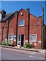
Ramsbury library
Ramsbury is fortunate in having its own branch library run by Wiltshire CC. The building was built as the Salvation Army 'barracks' in 1908, and there are names of various 'officers' on the foundation stones. This was probably the third building in the village that the SA had occupied, but they were not always popular in a village once known for its brewing trade.
Image: © Gordon Hatton
Taken: 3 Jun 2010
0.02 miles
4
![Ramsbury houses [14]](https://s0.geograph.org.uk/geophotos/06/44/62/6446244_24080de8_120x120.jpg)
Ramsbury houses [14]
Number 36 High Street is late 16th or early 17th century timber framed and thatched. Listed, grade II, with details at: https://historicengland.org.uk/listing/the-list/list-entry/1034094
Ramsbury lies in fertile farming land in the valley of the River Kennet. The site has been occupied since at least the Iron Age and there are several Roman villas. There was a bishopric of Ramsbury, established by 909 and ended in 1075 when it was included in the bishopric of Salisbury. Until 1744 when the present A4 road was turnpiked, the road through the village was part of the main route from London to Bristol.
Image: © Michael Dibb
Taken: 14 Mar 2020
0.02 miles
5
![Ramsbury houses [33]](https://s3.geograph.org.uk/geophotos/06/44/74/6447463_c514ee39_120x120.jpg)
Ramsbury houses [33]
Number 1 Burdett Street is a two storey, thatched detached house.
Ramsbury lies in fertile farming land in the valley of the River Kennet. The site has been occupied since at least the Iron Age and there are several Roman villas. There was a bishopric of Ramsbury, established by 909 and ended in 1075 when it was included in the bishopric of Salisbury. Until 1744 when the present A4 road was turnpiked, the road through the village was part of the main route from London to Bristol.
Image: © Michael Dibb
Taken: 14 Mar 2020
0.02 miles
6
![Ramsbury houses [16]](https://s0.geograph.org.uk/geophotos/06/44/62/6446248_a295897a_120x120.jpg)
Ramsbury houses [16]
This end of row house with an integral garage is number 55 High Street.
Ramsbury lies in fertile farming land in the valley of the River Kennet. The site has been occupied since at least the Iron Age and there are several Roman villas. There was a bishopric of Ramsbury, established by 909 and ended in 1075 when it was included in the bishopric of Salisbury. Until 1744 when the present A4 road was turnpiked, the road through the village was part of the main route from London to Bristol.
Image: © Michael Dibb
Taken: 14 Mar 2020
0.02 miles
7
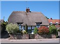
Thatch in Ramsbury
Thatched timber framed cottage on the High Street in Ramsbury. This is the only thatched cottage on the High Street, having survived the fire of 1781 which destroyed several others. Most property along the street is post 1781.
Image: © Gordon Hatton
Taken: 3 Jun 2010
0.02 miles
8
![Ramsbury buildings [9]](https://s3.geograph.org.uk/geophotos/06/44/62/6446243_072b9678_120x120.jpg)
Ramsbury buildings [9]
Ramsbury fire station is located in High Street.
Ramsbury lies in fertile farming land in the valley of the River Kennet. The site has been occupied since at least the Iron Age and there are several Roman villas. There was a bishopric of Ramsbury, established by 909 and ended in 1075 when it was included in the bishopric of Salisbury. Until 1744 when the present A4 road was turnpiked, the road through the village was part of the main route from London to Bristol.
Image: © Michael Dibb
Taken: 14 Mar 2020
0.03 miles
9
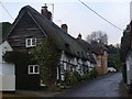
Burdett Street
Picturesque street in Ramsbury with black and white thatched cottages. The street connects High Street with Back Lane.
www.ramsbury.org
Image: © Colin Smith
Taken: 1 Feb 2011
0.03 miles
10
![Ramsbury houses [32]](https://s2.geograph.org.uk/geophotos/06/44/74/6447462_e50eb5b7_120x120.jpg)
Ramsbury houses [32]
Number 12 Burdett Street is a 17th century timber framed and thatched cottage. The rear extension is late 20th century. Listed, grade II, with details at: https://historicengland.org.uk/listing/the-list/list-entry/1365470
Ramsbury lies in fertile farming land in the valley of the River Kennet. The site has been occupied since at least the Iron Age and there are several Roman villas. There was a bishopric of Ramsbury, established by 909 and ended in 1075 when it was included in the bishopric of Salisbury. Until 1744 when the present A4 road was turnpiked, the road through the village was part of the main route from London to Bristol.
Image: © Michael Dibb
Taken: 14 Mar 2020
0.03 miles