IMAGES TAKEN NEAR TO
Ogbourne Maizey, MARLBOROUGH, SN8 1RY
Introduction
This page details the photographs taken nearby to SN8 1RY by members of the Geograph project.
The Geograph project started in 2005 with the aim of publishing, organising and preserving representative images for every square kilometre of Great Britain, Ireland and the Isle of Man.

There are currently over 7.5m images from over14,400 individuals and you can help contribute to the project by visiting https://www.geograph.org.uk
Image Map (Loading...)


Getting Data...Please wait
Leaflet Map data © OpenStreetMap
Images are licensed for reuse under creativecommons.org/licenses/by-sa/2.0
Notes
- Clicking on the map will re-center to the selected point.
- The higher the marker number, the further away the image location is from the centre of the postcode.
Image Listing (21 Images Found)
Images are licensed for reuse under creativecommons.org/licenses/by-sa/2.0
Image
Details
Distance

2
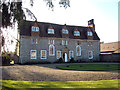
Ogbourne Maizey House
Grade II* listed house, http://www.britishlistedbuildings.co.uk/en-311297-ogbourne-maisey-house-ogbourne-st-andrew late 16th-early 17th century, altered in the early 18th century. Built of banded sarsen and knapped flint with a tiled roof, it has two storeys and attics, and cellars under the western third. It has a stone door case dating to 1636 with Ionic columns, entablature and pediment; the doorway is arched. It has five bays. On the ground floor, on either side of the doorway are early 18th century 18-pane sashes with heavy glazing bars. The outer bays have mid-18th century 12-pane sashes. Between, to the right of the entrance, is a round headed stair window; there is a balancing blind window to the left. The upper floor has 3-light stone mullioned windows. Above the eaves are three symmetrical gabled flush dormers, tile hung, with 17th century 3-light timber windows with diamond leading; between them are two similar recessed dormers. The gable ends have brick stacks, each with three diagonal brick shafts. The cellars to the right of the entrance have stone mullioned windows.
Image: © Vieve Forward
Taken: 2 Jan 2015
0.02 miles

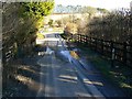
4
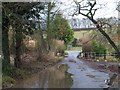
Flooding beside the River Og
The end of Rockley Road, where it meets the A346, with a bridge over the river.
Image: © David Smith
Taken: 30 Dec 2013
0.04 miles
5
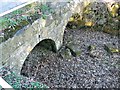
Bridge over the River Og, Ogbourne St Andrew, near Marlborough
The river bed is bone dry and contains leaf fall from last autumn implying that there has been no significant flow of water for many months.
Image: © Brian Robert Marshall
Taken: 5 Mar 2012
0.05 miles
6
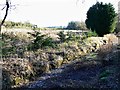
Course of the River Og, Ogbourne St Andrew, near Marlborough
At this time of year the course of the river should be full of water. Plainly it isn't. The winter of 2011/12 has seen low rainfall and minimal snow in these parts and the water table has fallen.
Image: © Brian Robert Marshall
Taken: 5 Mar 2012
0.06 miles
7
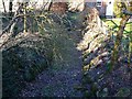
An upstream view of the course of the River Og, Ogbourne St Andrew, near Marlborough
The river has dried up completely and has been in this condition for months. At this time of year it should be running freely from its source in the downs south of Swindon. A mild and relatively dry winter has reduced it to this lifeless state.
Image: © Brian Robert Marshall
Taken: 5 Mar 2012
0.06 miles
8
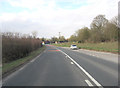
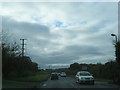
A346 enters Ogbourne St Andrew
The tiny River Og lends its name to a group of villages hereabouts 'The Ogbournes' and has carved its way through the chalk downs, creating a gap for this 'A' road to follow. Ogbourne means Occa's stream.
Image: © Stuart Logan
Taken: 29 Mar 2013
0.08 miles
9
Minor road from Rockley, Ogbourne St Andrew, Marlborough
The road terminates at a T junction with the A346 Chiseldon to Marlborough Road visible in the distance. It has rained recently but nowhere near enough to put water in the river close by http://www.geograph.org.uk/photo/2834980
Image: © Brian Robert Marshall
Taken: 5 Mar 2012
0.08 miles