IMAGES TAKEN NEAR TO
Restrop, Purton, SWINDON, SN5 4LW
Introduction
This page details the photographs taken nearby to SN5 4LW by members of the Geograph project.
The Geograph project started in 2005 with the aim of publishing, organising and preserving representative images for every square kilometre of Great Britain, Ireland and the Isle of Man.

There are currently over 7.5m images from over14,400 individuals and you can help contribute to the project by visiting https://www.geograph.org.uk
Image Map
Images are licensed for reuse under creativecommons.org/licenses/by-sa/2.0
Notes
- Clicking on the map will re-center to the selected point.
- The higher the marker number, the further away the image location is from the centre of the postcode.
Image Listing (5 Images Found)
Images are licensed for reuse under creativecommons.org/licenses/by-sa/2.0
Image
Details
Distance
1
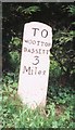
Old Milestone by Mud Lane, Restrop
Purton column by the UC road, in parish of Purton (North Wiltshire District), Restrop, by lane to Restrop Farm, corner of Mud Lane, in domestic hedge behind well kept triangle of grass.
Inscription reads:-
: TO / CRICKLADE / 5 / Miles : : TO / WOOTTON / BASSETT / 3 / Miles :
Grade II listed.
List Entry Number: 1023186 https://historicengland.org.uk/listing/the-list/list-entry/1023186
Surveyed
Milestone Society National ID: WI_CKWB03
Image: © Milestone Society
Taken: Unknown
0.08 miles
2
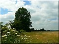
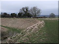
Not Mud Lane, Restrop, near Purton
There are two footpaths that approach Ringsbury Camp from the east. This is the one that isn't Mud Lane. The one that is is south of this one.
Image: © Brian Robert Marshall
Taken: 22 Jul 2008
0.18 miles
3
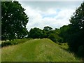
Ringsbury Camp, near Purton
This is a view facing south along the eastern boundary of the camp. The inner ditch is to the right. The camp has been dated to around 50 BC according to wiki http://en.wikipedia.org/wiki/Ringsbury_Camp
Image: © Brian Robert Marshall
Taken: 22 Jul 2008
0.22 miles
4
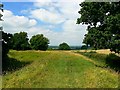
Ringsbury Camp, near Purton
Ringsbury Camp is a multivallate Iron Age hill-fort. In this north-facing view we can see the eastern part of the embankment. More here in wiki http://en.wikipedia.org/wiki/Ringsbury_Camp I haven't been able to find any other images of Ringsbury Camp on the web.
Image: © Brian Robert Marshall
Taken: 22 Jul 2008
0.22 miles
5
On the ramparts of Ringsbury Camp, near Dogridge, Purton
Ringsbury Camp is a multivallate Iron Age hillfort. The area occupied by the hillfort is almost coterminous with a small area of sandstone overlying the edge of the limestone escarpment here. This sandstone, formerly known as Rhaxella Chert, is now named the Ringsbury Spiculate Member after its location. The location for the hillfort was perhaps carefully chosen for certain qualities inherent in this rock.
Image: © Vieve Forward
Taken: 23 Mar 2010
0.22 miles