IMAGES TAKEN NEAR TO
Bampton Grove, SWINDON, SN3 1BS
Introduction
This page details the photographs taken nearby to Bampton Grove, SN3 1BS by members of the Geograph project.
The Geograph project started in 2005 with the aim of publishing, organising and preserving representative images for every square kilometre of Great Britain, Ireland and the Isle of Man.

There are currently over 7.5m images from over14,400 individuals and you can help contribute to the project by visiting https://www.geograph.org.uk
Image Map
Images are licensed for reuse under creativecommons.org/licenses/by-sa/2.0
Notes
- Clicking on the map will re-center to the selected point.
- The higher the marker number, the further away the image location is from the centre of the postcode.
Image Listing (70 Images Found)
Images are licensed for reuse under creativecommons.org/licenses/by-sa/2.0
Image
Details
Distance
1
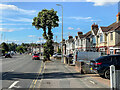
Drove Road
c.1930s housing in Drove Road, although the road itself is much older. the floodlights in the background are for Swindon Town FC's County Ground stadium.
Image: © Ian Capper
Taken: 14 Jul 2022
0.05 miles
2
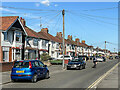
Cumberland Road
c.1930s housing in Cumberland Road, a side road off Drove Road.
Image: © Ian Capper
Taken: 14 Jul 2022
0.06 miles
3
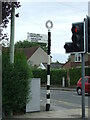
Direction Sign ? Signpost on the B4289 in Swindon
Located on the northeast side of the crossroads of the B4289 Drove Road, Cumberland Road and Groundwell Road, Central Swindon South parish. 2 arms and annulus finial.
Milestone Society National ID: WI_SU1584B
Image: © John V Nicholls
Taken: 28 Jun 2009
0.07 miles
4
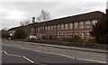
Drove Primary School, Swindon
The large school on the west side of Drove Road has about 550 pupils enrolled, ages 3-11.
Image: © Jaggery
Taken: 14 Apr 2013
0.08 miles
5
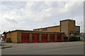
Swindon Fire Station
Swindon Fire Station, Drove Road, Swindon, Wiltshire
Image: © Kevin Hale
Taken: 8 May 2007
0.08 miles
6
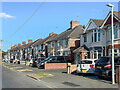
Dudmore Road
c.1930s housing in Dudmore Road, a side road off Drove Road.
Image: © Ian Capper
Taken: 14 Jul 2022
0.08 miles
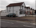
7
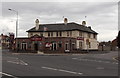
The Merlin, Swindon
Pub on the corner of Southampton Street and Groundwell Road, viewed across the B4289 Drove Road.
Image: © Jaggery
Taken: 14 Apr 2013
0.08 miles
8
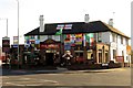
The Merlin on Drove Road
The Merlin was formerly a Morrells pub called the Oxford.
Image: © Steve Daniels
Taken: 25 Jun 2014
0.08 miles
9
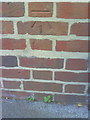
Benchmark on Drove School at dusk
Ordnance Survey cut mark benchmark described on the Bench Mark Database at http://www.bench-marks.org.uk/bm35752
Image: © Roger Templeman
Taken: 15 Oct 2010
0.09 miles
10
Chic Boutique, Swindon
Women's fashion clothes shop at 19 Drove Road, on the corner of Dudmore Road.
Image: © Jaggery
Taken: 14 Apr 2013
0.09 miles