IMAGES TAKEN NEAR TO
Pickwick Close, SWINDON, SN2 7TH
Introduction
This page details the photographs taken nearby to Pickwick Close, SN2 7TH by members of the Geograph project.
The Geograph project started in 2005 with the aim of publishing, organising and preserving representative images for every square kilometre of Great Britain, Ireland and the Isle of Man.

There are currently over 7.5m images from over14,400 individuals and you can help contribute to the project by visiting https://www.geograph.org.uk
Image Map
Images are licensed for reuse under creativecommons.org/licenses/by-sa/2.0
Notes
- Clicking on the map will re-center to the selected point.
- The higher the marker number, the further away the image location is from the centre of the postcode.
Image Listing (12 Images Found)
Images are licensed for reuse under creativecommons.org/licenses/by-sa/2.0
Image
Details
Distance
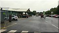
1
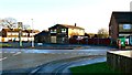
Queensfield and its pub, Swindon
Sadly, the public house in the background is now closed, empty and boarded up. Queensfield itself is a typical 1960s residential development that normally would not generate much news. However, its geographical location is such that it provides an opportunity for 'rat-running' between areas to the west and the east, particularly at peak times. The local authority has introduced temporary bans on through traffic at peak hours, which inevitably pleased some and upset others. At present I'm not sure whether the ban is in place or not http://www.swindonadvertiser.co.uk/news/10350038.Don_t_bring_back_Queensfield_traffic_ban__say_residents/
Image: © Brian Robert Marshall
Taken: 2 Jan 2014
0.16 miles
2
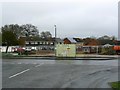
The Queensfield pub, Queensfield, Swindon
The pub is typical of its age, about 45 years old or thereabouts. Typically also, it is closed, empty and boarded up. It has had a chequered history in the last 4 years or so. It closed some time before 2009 then re-opened in March of that year http://www.swindonadvertiser.co.uk/news/4239602.Queensfield_pub_reopens_in_Swindon_with_Easter_raffle/ Then it closed again in September 2011 http://www.swindonadvertiser.co.uk/news/9257895.Last_orders_for_popular_publican/ It must have subsequently re-opened because in June 2013 it closed yet again http://www.swindonadvertiser.co.uk/news/10460241.Upper_Stratton_local_closes_yet_again/?ref=ar The last mention so far is December 2013 when it appears that the pub will be demolished to make way for new housing http://www.swindonadvertiser.co.uk/news/10903381.New_homes_may_be_built_on_site_of_pub/
Image: © Brian Robert Marshall
Taken: 2 Jan 2014
0.16 miles
3
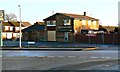
Site of the Queensfield pub, Queensfield, Swindon
The failed pub seen here two years ago Image has been demolished. No-one seems to have mourned its passing. The site will probably be used for new housing.
Image: © Brian Robert Marshall
Taken: 21 Feb 2016
0.16 miles
4

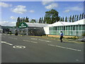
Wyevale Garden Centre Hyde Road Swindon
A popular weekend destination for gardeners of all persuasions.
Image: © Brian Robert Marshall
Taken: 4 Nov 2006
0.20 miles
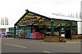
5
Swindon Garden Centre, 2
Part of the Garden Centre Group that owns Wyevale.
Sited right next to the Ermin Way Roman Road.
See the first Geograph for this gridsquare; Image taken in 2006.
Note that the conservatories are now gone to make way for the new entrance into the Plant Area, see Image
Image: © Jonathan Billinger
Taken: 30 Aug 2015
0.20 miles
6
The Swindon Garden Centre on Hyde Road
Image: © Steve Daniels
Taken: 1 Dec 2013
0.20 miles
7
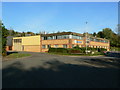
TSSI Systems Ltd Groundwell Industrial Estate Swindon
TSSI Systems Ltd are a new company specialising in biometrics and fingerprint recognition systems.
Image: © Brian Robert Marshall
Taken: 4 Nov 2006
0.20 miles
8
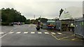
Swindon Garden Centre, 1
Part of the Garden Centre Group that owns Wyevale.
Sited right next to the Ermin Way Roman Road.
Image: © Jonathan Billinger
Taken: 30 Aug 2015
0.21 miles
9
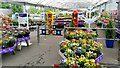
Swindon Garden Centre, 3
Part of the Garden Centre Group that owns Wyevale.
This is the colourful entrance display.
Image: © Jonathan Billinger
Taken: 30 Aug 2015
0.21 miles