IMAGES TAKEN NEAR TO
School Lane, CHIPPENHAM, SN14 7HJ
Introduction
This page details the photographs taken nearby to School Lane, SN14 7HJ by members of the Geograph project.
The Geograph project started in 2005 with the aim of publishing, organising and preserving representative images for every square kilometre of Great Britain, Ireland and the Isle of Man.

There are currently over 7.5m images from over14,400 individuals and you can help contribute to the project by visiting https://www.geograph.org.uk
Image Map
Images are licensed for reuse under creativecommons.org/licenses/by-sa/2.0
Notes
- Clicking on the map will re-center to the selected point.
- The higher the marker number, the further away the image location is from the centre of the postcode.
Image Listing (60 Images Found)
Images are licensed for reuse under creativecommons.org/licenses/by-sa/2.0
Image
Details
Distance
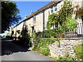
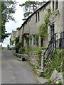
2
![Castle Combe [3] - School Lane](https://s0.geograph.org.uk/geophotos/05/28/51/5285188_fffc24d1_120x120.jpg)
Castle Combe [3] - School Lane
The middle cottage of the three is 18th century and is listed, grade II, with details at: https://www.historicengland.org.uk/listing/the-list/list-entry/1199176
The old school, seen beyond the cottages, was built in 1826 and closed in 1998. It also listed, grade II, with details at: https://www.historicengland.org.uk/listing/the-list/list-entry/1363550
The 'chocolate box' village has over 50 listed buildings and there are over 25 listed monuments in the churchyard.
Image: © Michael Dibb
Taken: 14 Feb 2017
0.02 miles
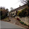
3
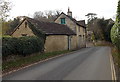
Hillside Cottage, Castle Combe
Viewed across The Street on the descent towards the centre of the village.
Image: © Jaggery
Taken: 24 Nov 2013
0.02 miles
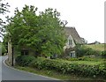
4
![Castle Combe [4] - Hill Cottage](https://s1.geograph.org.uk/geophotos/05/28/51/5285189_0c7965ea_120x120.jpg)
Castle Combe [4] - Hill Cottage
This cottage is 18th century although the rear wing is probably 19th century. Listed, grade II, with details at: https://www.historicengland.org.uk/listing/the-list/list-entry/1199026
The 'chocolate box' village has over 50 listed buildings and there are over 25 listed monuments in the churchyard.
Image: © Michael Dibb
Taken: 14 Feb 2017
0.02 miles
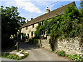
5
Castle Combe - Hill Cottage
Hill Cottage (not to be confused with Hill House further down the hill) is almost opposite the entrance to Image], as with numerous properties in Castle Combe it is Grade II listed http://list.english-heritage.org.uk/resultsingle.aspx?uid=1199026&searchtype=mapsearch
Image: © Rob Farrow
Taken: 8 Sep 2013
0.02 miles
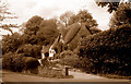
6
The Way to Nettleton Shrub
A walking route from Castle Combe to Nettleton Shrub branches off from the main street into Nettleton as shown here.
Image: © Pam Brophy
Taken: 23 Aug 2005
0.03 miles
7
Castle Combe - School Lane
School Lane is somewhat distant from the main village of Castle Combe, almost being in Upper Castle Combe. There are two listed buildings in this short lane: No. 2 School Lane http://list.english-heritage.org.uk/resultsingle.aspx?uid=1199176&searchtype=mapsearch
and
The Primary School http://list.english-heritage.org.uk/resultsingle.aspx?uid=1363550&searchtype=mapsearch
Image: © Rob Farrow
Taken: 8 Sep 2013
0.03 miles
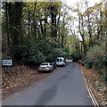
8
School Lane, Castle Combe
A wooden post shows SCHOOL LANE PRIVATE ROAD and a No Entry sign which obviously doesn't apply to residents of School Lane. A black arrow points along the road descending towards Castle Combe village. A yellow arrow directs walkers along School Lane towards Nettleton Shrub (2½ miles).
Image: © Jaggery
Taken: 24 Nov 2013
0.03 miles
10
Northern boundary of Castle Combe
The Street descends towards the centre of the small village in NW Wiltshire.
Image: © Jaggery
Taken: 24 Nov 2013
0.03 miles