IMAGES TAKEN NEAR TO
Chequers, CORSHAM, SN13 0QG
Introduction
This page details the photographs taken nearby to SN13 0QG by members of the Geograph project.
The Geograph project started in 2005 with the aim of publishing, organising and preserving representative images for every square kilometre of Great Britain, Ireland and the Isle of Man.

There are currently over 7.5m images from over14,400 individuals and you can help contribute to the project by visiting https://www.geograph.org.uk
Image Map
Images are licensed for reuse under creativecommons.org/licenses/by-sa/2.0
Notes
- Clicking on the map will re-center to the selected point.
- The higher the marker number, the further away the image location is from the centre of the postcode.
Image Listing (7 Images Found)
Images are licensed for reuse under creativecommons.org/licenses/by-sa/2.0
Image
Details
Distance
1
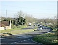
2008 : The A4 heads for Chippenham
Passing Chequers Farm on the left. The convenient layby is the result of road realignment.
Traffic : pylons
Image: © Maurice Pullin
Taken: 1 Dec 2008
0.03 miles
2
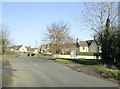
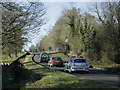
2008 : Crossroads at Chequers Farm
The road behind comes from Notton, straight on it goes to Biddestone and the road crossing is the A4 between Bath and Chippenham.
Image: © Maurice Pullin
Taken: 1 Dec 2008
0.03 miles
4
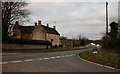
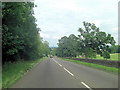
2008 : The A4 heads for Bath
The land to the left of the road here is part of Corsham Park, laid out in 1760 by Lancelot "Capability" Brown under the instructions of the Lord of the Manor, Paul Methuen.
Image: © Maurice Pullin
Taken: 1 Dec 2008
0.11 miles
6
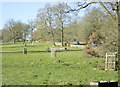
2008 : Corsham Park
The north east corner. The A4 passes to the right.
"The permissive open access has been created to enable the walker to freely wander off the footpath in this landscape created by Repton and Brown, for the first time viewing the lake at close quarters. The access also allows the public to see some of the restoration being carried out under the Countryside Stewardship Scheme. This includes the lake itself, and a considerable number of parkland trees in the park."
The above was copied from: http://cwr.defra.gov.uk/Default.aspx?Module=CountryWalkDetails&Site=2552
Image: © Maurice Pullin
Taken: 1 Dec 2008
0.13 miles
7
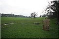
Parkland
Looking along the footpath that runs through Corsham Park.
Image: © Derek Hawkins
Taken: 18 Feb 2007
0.16 miles