IMAGES TAKEN NEAR TO
Quakers Lane, CALNE, SN11 9JG
Introduction
This page details the photographs taken nearby to Quakers Lane, SN11 9JG by members of the Geograph project.
The Geograph project started in 2005 with the aim of publishing, organising and preserving representative images for every square kilometre of Great Britain, Ireland and the Isle of Man.

There are currently over 7.5m images from over14,400 individuals and you can help contribute to the project by visiting https://www.geograph.org.uk
Image Map
Images are licensed for reuse under creativecommons.org/licenses/by-sa/2.0
Notes
- Clicking on the map will re-center to the selected point.
- The higher the marker number, the further away the image location is from the centre of the postcode.
Image Listing (14 Images Found)
Images are licensed for reuse under creativecommons.org/licenses/by-sa/2.0
Image
Details
Distance
1

Corton House, Quakers Lane, Goatacre
Grade II listed http://www.britishlistedbuildings.co.uk/en-316381-corton-house-hilmarton- stone-built slate-roofed estate house, built circa 1850. The mullioned casement windows have hoodmoulds. The door is set in a large squared rubble porch with a slate roof, and has a gable finial and Tudor-arched entry with hoodmould. Now a kennels and cattery.
Image: © Vieve Forward
Taken: 27 Dec 2014
0.00 miles
2
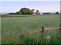
Farmland, near Catcomb Farm, Catcomb
Behind the viewpoint is an electricity sub-station discernible on the maps. Catcomb Farm, seen in this image, is at SU009768. The image was taken as the sun was sinking towards the horizon meaning that the colours are somewhat muted.
Image: © Brian Robert Marshall
Taken: 10 Jun 2008
0.14 miles
3
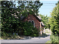
2011 : Chapel in the trees on the road to New Zealand
Seen from Quakers Walk, Goatacre.
The A3102 passes a few yards to the right.
Image: © Maurice Pullin
Taken: 3 Jun 2011
0.18 miles
4
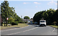
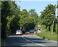
2011 : A3102 at Goatacre
Heading south to Hilmarton and Calne.
Image: © Maurice Pullin
Taken: 3 Jun 2011
0.20 miles
5
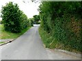
Goatacre Lane, Goatacre
The lane is seen heading north-west to a 'T' junction where it meets the A3102 between Lyneham and Calne. Turn left for Calne.
Image: © Brian Robert Marshall
Taken: 10 Jun 2008
0.22 miles
6
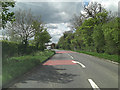
2011 : A3102 leaving Goatacre
Heading north for Lyneham, about one mile away.
Image: © Maurice Pullin
Taken: 3 Jun 2011
0.23 miles
7
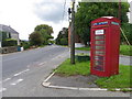
A3102 and telephone box, Goatacre
The K6 type telephone box stands beside the A3102.
In 1935, the Post Office commissioned a new kiosk from Sir Giles Gilbert Scott to celebrate the Jubilee of King George V. The K6 Jubilee Kiosk, as it is known, was similar to the K2 box, being made of cast iron and painted red but was 25% lighter in weight. By the end of the 1930s there were 20,000 K6 telephone boxes in use all over the UK.
Image: © Maigheach-gheal
Taken: 27 Aug 2010
0.23 miles
9
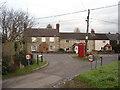
Quakers Lane, Goatacre
Houses at the junction of Quakers Lane, Goatacre, and the main A3102 Lyneham-Calne road.
Image: © Vieve Forward
Taken: 27 Dec 2014
0.24 miles
10
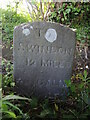
To and from Wiltshire towns
A milestone at the south end of the A3102 near Goatacre stands on the downslope of a bank lining the road. Thankfully it has survived, but is rather obscured from road-users by a heavy layer of vegetation. See Image
Image: © Neil Owen
Taken: 28 May 2022
0.24 miles