IMAGES TAKEN NEAR TO
Carshalton Road, BANSTEAD, SM7 3HZ
Introduction
This page details the photographs taken nearby to Carshalton Road, SM7 3HZ by members of the Geograph project.
The Geograph project started in 2005 with the aim of publishing, organising and preserving representative images for every square kilometre of Great Britain, Ireland and the Isle of Man.

There are currently over 7.5m images from over14,400 individuals and you can help contribute to the project by visiting https://www.geograph.org.uk
Image Map
Images are licensed for reuse under creativecommons.org/licenses/by-sa/2.0
Notes
- Clicking on the map will re-center to the selected point.
- The higher the marker number, the further away the image location is from the centre of the postcode.
Image Listing (77 Images Found)
Images are licensed for reuse under creativecommons.org/licenses/by-sa/2.0
Image
Details
Distance
1
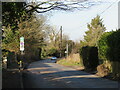
Carshalton Road, near Banstead
Carshalton Road forms part of the route of the B278. Here, the road crosses the border from Surrey into Greater London. The road signs indicate that parking restrictions change at the boundary.
This road is on route 20 of the National Cycle Network.
Image: © Malc McDonald
Taken: 19 Feb 2023
0.09 miles
2
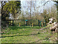
Footpath exit to Carshalton Road
Used by the London Loop long distance path, adding somewhat to the distance locally, to avoid too much walking on busy roads with no footway or reasonable verge. This route turns left down the road for a bit here, again with no footway, but less busy than the shorter route.
Image: © Robin Webster
Taken: 30 Mar 2012
0.10 miles
3
Footpath to Carshalton Road
Used by the London Loop long distance path, adding somewhat to the distance locally, to avoid too much walking on busy roads.
Image: © Robin Webster
Taken: 30 Mar 2012
0.10 miles
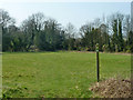
4
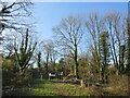
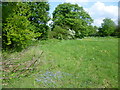
Public footpath into meadow near Banstead
A public footpath into a meadow close to the border of Greater London and Surrey. This location is within Greater London.
This image was taken on a February afternoon. Many of the trees were bare for the winter season, and cast long shadows as the sun is low in the sky at this time of year.
Image: © Malc McDonald
Taken: 19 Feb 2023
0.10 miles
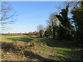
5
Public footpath near Banstead
A public footpath heading out of a meadow close to the border of Greater London and Surrey. This point is within Greater London.
This image was taken on a February afternoon. Trees were bare for the winter season.
Image: © Malc McDonald
Taken: 19 Feb 2023
0.10 miles
6
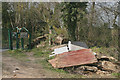
London Loop footpath at Carshalton Road north of Woodmansterne
This area has somewhat deteriorated since Geograph Image was taken. More domestic waste is to be found in neighbouring fields.
Image: © David Kemp
Taken: 8 Apr 2015
0.11 miles
7
Mayfield Lavender Farm, Banstead, Surrey
Image: © Christine Matthews
Taken: 7 Jul 2016
0.13 miles
8
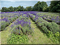
Mayfield Lavender Farm, Banstead, Surrey
Image: © Christine Matthews
Taken: 7 Jul 2016
0.13 miles
9
Mayfield Lavender Farm, Banstead, Surrey
Image: © Christine Matthews
Taken: 7 Jul 2016
0.13 miles
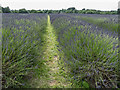
10
View from the London LOOP
The London LOOP here is on its way from Grove Lane to The Oaks Park. It has just passed along Carshalton Road, and Mayfield Lavender Fields are on the other side of the treeline on the left.
Image: © Marathon
Taken: 30 Apr 2014
0.14 miles