IMAGES TAKEN NEAR TO
Moth Close, WALLINGTON, SM6 9GR
Introduction
This page details the photographs taken nearby to Moth Close, SM6 9GR by members of the Geograph project.
The Geograph project started in 2005 with the aim of publishing, organising and preserving representative images for every square kilometre of Great Britain, Ireland and the Isle of Man.

There are currently over 7.5m images from over14,400 individuals and you can help contribute to the project by visiting https://www.geograph.org.uk
Image Map
Images are licensed for reuse under creativecommons.org/licenses/by-sa/2.0
Notes
- Clicking on the map will re-center to the selected point.
- The higher the marker number, the further away the image location is from the centre of the postcode.
Image Listing (28 Images Found)
Images are licensed for reuse under creativecommons.org/licenses/by-sa/2.0
Image
Details
Distance
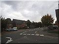
1
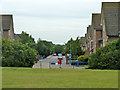
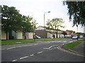
Jean Batten Close and Lancastrian Road, Roundshaw
A housing development built on part of the old Croydon Airport.
Image: © Robin Webster
Taken: 6 Jun 2011
0.04 miles
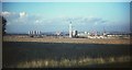
2
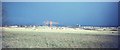
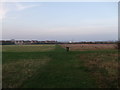
Former Croydon aerodrome, 1967
A view from Foresters Drive across the disused airfield. The cranes are at work building the Roundshaw estate, in Image Beyond, very hazy in cloud, is Croydon. Left of the cranes can be seen the coal-fired Croydon B power station near Waddon.
Image: © Derek Harper
Taken: Unknown
0.12 miles
3
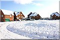
Spitfire Close, Roundshaw.
This is a new part of the Roundshaw Estate, Wallington , Surrey, which has recently undergone a massive Regeneration. This Estate first built in the 1960s, was built on the site of Londons first Airport, near Croydon. All the streets on the Estate have been named after aircraft or have connotations with the industry.
Image: © Craig Janes
Taken: 3 Feb 2009
0.14 miles
4
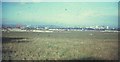
Former Croydon aerodrome, 1967
Overlapping with Image on the left, and with a clearer view towards the tower blocks of Croydon. Left of centre on the horizon can faintly be seen the Crystal Palace TV transmitter. The area in the foreground later became allotments.
Image: © Derek Harper
Taken: Unknown
0.15 miles
5
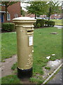
Wallington: postbox № SM6 42, Mollison Drive
An Elizabeth II-reign postbox near the corner of Spitfire Road. Paralympic gold medallist David Weir had four postboxes officially painted gold by Royal Mail, but only one at the nearby post office (see Image) and the one in Wallington town centre (see Image) appear on the gold postboxes website http://www.goldpostboxes.com/ .
Image: © Chris Downer
Taken: 20 Oct 2012
0.16 miles
6
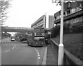
Mollison Drive, Roundshaw, Surrey
The Roundshaw estate was developed in the 1970s on land previously occupied by Croydon Airport.
The bridge over the road here was later demolished owing to hooliganism.
Image: © Dr Neil Clifton
Taken: 21 Apr 1980
0.16 miles
7
Mollison Drive, Roundshaw
The Roundshaw Estate occupies some of the site of Croydon Airport, as the aircraft-themed names of many of its streets indicate.
Image: © Christopher Hilton
Taken: 6 Jun 2014
0.17 miles
8
A junction of paths in Roundshaw Recreational Ground
A path leads from Plough Lane into the large open-space ground near Roundshaw.
Croydon is seen in the background.
Image: © David Anstiss
Taken: 13 Nov 2011
0.18 miles
10
Former Croydon aerodrome, 1967
The view looks across the chalk grassland of the aerodrome, which closed in 1959. There is now woodland and allotments in the foreground area. Showing the progress on the Roundshaw estate since Image was taken, with a tall chimney on the communal boiler house of a centralised heating system. The first tenants had moved in to the estate the previous month. To its left is the Croydon B power station and some cooling towers; central Croydon is to the right.
Image: © Derek Harper
Taken: Unknown
0.20 miles