IMAGES TAKEN NEAR TO
East Drive, CARSHALTON, SM5 4PA
Introduction
This page details the photographs taken nearby to East Drive, SM5 4PA by members of the Geograph project.
The Geograph project started in 2005 with the aim of publishing, organising and preserving representative images for every square kilometre of Great Britain, Ireland and the Isle of Man.

There are currently over 7.5m images from over14,400 individuals and you can help contribute to the project by visiting https://www.geograph.org.uk
Image Map
Images are licensed for reuse under creativecommons.org/licenses/by-sa/2.0
Notes
- Clicking on the map will re-center to the selected point.
- The higher the marker number, the further away the image location is from the centre of the postcode.
Image Listing (31 Images Found)
Images are licensed for reuse under creativecommons.org/licenses/by-sa/2.0
Image
Details
Distance
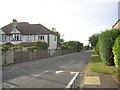
1
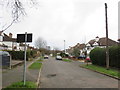
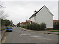
East Drive, Carshalton
East Drive is a residential road in Carshalton, in south London's outer suburbs.
Image: © Malc McDonald
Taken: 11 Jan 2020
0.03 miles
2
Fountain Drive at the Dingwall Road / East Drive crossing
South of Carshalton village centre, Fountain Drive - the former entrance driveway - climbs towards the site of the former Queen Mary Hospital. Here, two roads approach it as if to cross it - East Drive from the west and Dingwall Road to the east - but each is blocked to road traffic by a wall. There is a degree of social separation across the entrance driveway - Dingwall Road lies within an apparent former council estate, whilst East Drive comprises more expensive private housing – and this reflects the fact that originally the walls were a solid barrier even to pedestrians. During the Second World War gaps were created in the walls to facilitate access to and from the hospital from the nearby residential areas; after the War it was intended to reinstate the barriers but local pressure prevented this, residents finding that the hospital’s entrance provided, for instance, a swift route to Carshalton Beeches station. Pedestrians are allowed through to this day, but there has never been an open road crossing.
My thanks to John Hyde (http://www.geograph.org.uk/profile/122976 ) for making this layout clear.
Image: © Christopher Hilton
Taken: 4 Jul 2014
0.04 miles
3
Dingwall Road, Carshalton
South of Carshalton village centre, Fountain Drive - the former entrance driveway - climbs towards the site of the former Queen Mary Hospital. Here, two roads approach it as if to cross it - East Drive from the west and Dingwall Road to the east - but each is blocked to road traffic by a wall. There is a degree of social separation across the entrance driveway - Dingwall Road lies within an apparent former council estate, whilst East Drive comprises more expensive private housing – and this reflects the fact that originally the walls were a solid barrier even to pedestrians. During the Second World War gaps were created in the walls to facilitate access to and from the hospital from the nearby residential areas; after the War it was intended to reinstate the barriers but local pressure prevented this, residents finding that the hospital’s entrance provided, for instance, a swift route to Carshalton Beeches station. Pedestrians are allowed through to this day, but there has never been an open road crossing.
My thanks to John Hyde (http://www.geograph.org.uk/profile/122976 ) for making this layout clear.
Image: © Christopher Hilton
Taken: 4 Jul 2014
0.04 miles
4
Fountain Drive at the Dingwall Road / East Drive crossing
South of Carshalton village centre, Fountain Drive - the former entrance driveway - climbs towards the site of the former Queen Mary Hospital. Here, two roads approach it as if to cross it - East Drive from the west and Dingwall Road to the east - but each is blocked to road traffic by a wall. There is a degree of social separation across the entrance driveway - Dingwall Road lies within an apparent former council estate, whilst East Drive comprises more expensive private housing – and this reflects the fact that originally the walls were a solid barrier even to pedestrians. During the Second World War gaps were created in the walls to facilitate access to and from the hospital from the nearby residential areas; after the War it was intended to reinstate the barriers but local pressure prevented this, residents finding that the hospital’s entrance provided, for instance, a swift route to Carshalton Beeches station. Pedestrians are allowed through to this day, but there has never been an open road crossing.
My thanks to John Hyde (http://www.geograph.org.uk/profile/122976 ) for making this layout clear.
Image: © Christopher Hilton
Taken: 4 Jul 2014
0.06 miles
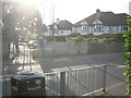
5
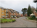
Diamond Jubilee Way, Carshalton
Diamond Jubilee Way was formerly the driveway into a hospital. The hospital closed in 1993 and the site has been redeveloped for housing.
Image: © Malc McDonald
Taken: 11 Jan 2020
0.06 miles
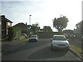
6
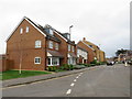
Damson Way, Carshalton
Damson Way forms part of a housing development on the site of a former hospital in Carshalton, in the outer suburbs of south London. The hospital closed in 1993.
Image: © Malc McDonald
Taken: 11 Jan 2020
0.06 miles
7
Diamond Jubilee Way, Carshalton
Diamond Jubilee Way in Carshalton, in the outer suburbs of south London. This street forms part of a recently-built housing development on a site formerly occupied by a hospital. The hospital had closed in 1993.
Image: © Malc McDonald
Taken: 11 Jan 2020
0.07 miles
8
Former Queen Mary's Hospital, Carshalton Beeches
A former NHS site much of which now seems to be a modern housing estate (behind and to the left of photographer). Signs indicate that a number of clinics still operate here, including perhaps the main building on the left, while the three other buildings visible are disused and boarded-up. See here for a fuller history: Image]
Image: © Stephen Richards
Taken: Unknown
0.11 miles
9
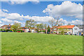
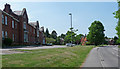
Courtney Crescent
Large green at the top of Courtney Crescent, first marked on the 1935 25 inch map.
Image: © Ian Capper
Taken: 25 Apr 2023
0.12 miles
10
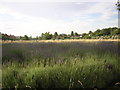
Lavender meadow and allotments, behind the houses on Stanley Square
Lavender has long been grown in this area of the North Downs: Christmas decorations in the London Borough of Sutton take the form of illuminated lavender, local scout troupes wear it as their distinguishing shoulder patch, and so forth. The crop is still grown commercially at a few locations in the area.
Image: © Christopher Hilton
Taken: 4 Jul 2014
0.15 miles