IMAGES TAKEN NEAR TO
Park Lane, CARSHALTON, SM5 3EE
Introduction
This page details the photographs taken nearby to Park Lane, SM5 3EE by members of the Geograph project.
The Geograph project started in 2005 with the aim of publishing, organising and preserving representative images for every square kilometre of Great Britain, Ireland and the Isle of Man.

There are currently over 7.5m images from over14,400 individuals and you can help contribute to the project by visiting https://www.geograph.org.uk
Image Map
Images are licensed for reuse under creativecommons.org/licenses/by-sa/2.0
Notes
- Clicking on the map will re-center to the selected point.
- The higher the marker number, the further away the image location is from the centre of the postcode.
Image Listing (29 Images Found)
Images are licensed for reuse under creativecommons.org/licenses/by-sa/2.0
Image
Details
Distance
1
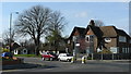
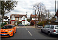
Junction of Ruskin Road and Park Lane
Traffic waits to exit Ruskin Road.
Image: © Peter Trimming
Taken: 17 Mar 2009
0.11 miles
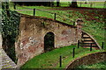
2
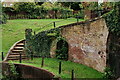
Carshalton Park
The park today occupies an area of 9.28 hectares, which is about one tenth of its original size.
The Grotto is situated in the south-east corner of the park. It was built in about 1724 as one of the first features of the ambitious designs for building and landscaping in the park.
A branch of the River Wandle used to rise in a subterranean chalk chamber beneath the Grotto. Within the recent past, water has again been seen at this location. View from above the Grotto.
Image: © Peter Trimming
Taken: 2 Oct 2024
0.13 miles
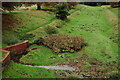
3
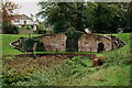
Carshalton Park: dry watercourse
Along the east side of Carshalton Park, this depression leading down from what appears to be a spring or fountain-head is clearly intended as a watercourse, but in a dry spring the bed showed no signs of water.
Image: © Christopher Hilton
Taken: 30 Mar 2012
0.14 miles
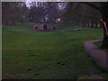
4

Firework display, Carshalton Park
Image: © Christopher Hilton
Taken: 5 Nov 2011
0.14 miles
5
Carshalton Park
The park today occupies an area of 9.28 hectares, which is about one tenth of its original size.
The Grotto is situated in the south-east corner of the park. It was built in about 1724 as one of the first features of the ambitious designs for building and landscaping in the park.
A branch of the River Wandle used to rise in a subterranean chalk chamber beneath the Grotto. Within the recent past, water has again been seen at this location.
Image: © Peter Trimming
Taken: 2 Oct 2024
0.14 miles
6
Carshalton Park
The park today occupies an area of 9.28 hectares, which is about one tenth of its original size.
The Grotto is situated in the south-east corner of the park. It was built in about 1724 as one of the first features of the ambitious designs for building and landscaping in the park.
A branch of the River Wandle used to rise in a subterranean chalk chamber beneath the Grotto. Within the recent past, water has again been seen at this location.
Image: © Peter Trimming
Taken: 2 Oct 2024
0.14 miles
7
Carshalton Park
The park today occupies an area of 9.28 hectares, which is about one tenth of its original size.
The Grotto is situated in the south-east corner of the park. It was built in about 1724 as one of the first features of the ambitious designs for building and landscaping in the park.
A branch of the River Wandle used to rise in a subterranean chalk chamber beneath the Grotto. Within the recent past, water has again been seen at this location.
Image: © Peter Trimming
Taken: 2 Oct 2024
0.14 miles
8
Carshalton: Talbot Road
Looking east to where Talbot Road joins Rotherfield Road in a T-junction, we see one of the ornamental sewer vent pipes, this one having lost its crown, which would have been at the top.
Image: © Dr Neil Clifton
Taken: 16 Apr 2012
0.15 miles
9
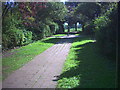
Footpath between Ruskin Road (B271) and Talbot Road, Carshalton.
Image: © Noel Foster
Taken: 31 Aug 2005
0.15 miles
10

Firework display, Carshalton Park
Image: © Christopher Hilton
Taken: 5 Nov 2011
0.15 miles