IMAGES TAKEN NEAR TO
Whitby Road, SUTTON, SM1 3NB
Introduction
This page details the photographs taken nearby to Whitby Road, SM1 3NB by members of the Geograph project.
The Geograph project started in 2005 with the aim of publishing, organising and preserving representative images for every square kilometre of Great Britain, Ireland and the Isle of Man.

There are currently over 7.5m images from over14,400 individuals and you can help contribute to the project by visiting https://www.geograph.org.uk
Image Map
Images are licensed for reuse under creativecommons.org/licenses/by-sa/2.0
Notes
- Clicking on the map will re-center to the selected point.
- The higher the marker number, the further away the image location is from the centre of the postcode.
Image Listing (15 Images Found)
Images are licensed for reuse under creativecommons.org/licenses/by-sa/2.0
Image
Details
Distance
2
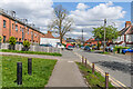
St. Helier: Westminster Road
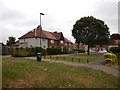
The inter-war St. Helier council estate was not built with the motor car in mind.
Image: © Dr Neil Clifton
Taken: 28 Jul 2013
0.15 miles
3
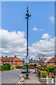
Sewer vent column, Duke of Edinburgh Road
Sewer vent column in Duke of Edinburgh Road, one of at least 31 such columns in the old Carshalton UDC area (see description below - this is no 9 on the map). This example has the arrow below the globe at the top of the column. Grade II listed - see https://historicengland.org.uk/listing/the-list/list-entry/1468630?section=official-list-entry. For a wider view see Image The terraces in the background are in Westminster Road and Whitby Road.
Image: © Ian Capper
Taken: 25 Apr 2023
0.16 miles
4
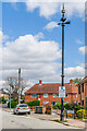
Sewer vent column, Duke of Edinburgh Road
Sewer vent column in Duke of Edinburgh Road, one of at least 31 such columns in the old Carshalton UDC area (see description below - this is no 9 on the map). This example has the arrow below the globe at the top of the column. Grade II listed - see https://historicengland.org.uk/listing/the-list/list-entry/1468630?section=official-list-entry. For a wider view see Image The terrace in the background is in Westminster Road.
Image: © Ian Capper
Taken: 25 Apr 2023
0.17 miles
5
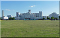
St Helier Hospital, Rosehill
Pevsner sums it up with "big, tall and broad ... in a utilitarian modern idiom". By Saxon Snell and Phillips in 1938. He omitted to mention its whiteness.
It is conspicuous in views from high points across south London, due to its bigness, tallness, whiteness, and the flat green expanse in front of it.
Image: © Stephen Richards
Taken: Unknown
0.18 miles
6
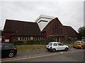
Bishop Andrewes' Church of England - Built 1932
Website : http://www.parishofsthelier.co.uk/about-us/bishop-andrewes
Image: © James Emmans
Taken: 2 Sep 2016
0.18 miles
7
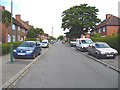
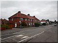
Duke of Edinburgh Road
Houses in Duke of Edinburgh Road, a road marked on the 1898 6 inch map and 1913 25 inch map (both simply as Edinburgh Road) only with a few houses at its northern end, where the terrace on the left in this photo now stand. The houses on the right are later, being first shown on the 1935 25 inch map (with the road named as currently). In the right background is the sewer vent column in Image and Image
Image: © Ian Capper
Taken: 25 Apr 2023
0.18 miles
9
St. Helier Hospital
Serving a large area of South London
Image: © Dr Neil Clifton
Taken: 28 Jul 2013
0.20 miles
10
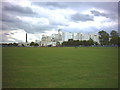
St Helier Hospital, Wrythe Lane, Sutton.
This large white building is visible on the skyline from quite large distances.
Image: © Noel Foster
Taken: 6 Jul 2005
0.20 miles