IMAGES TAKEN NEAR TO
Sandpiper Road, SUTTON, SM1 2UF
Introduction
This page details the photographs taken nearby to Sandpiper Road, SM1 2UF by members of the Geograph project.
The Geograph project started in 2005 with the aim of publishing, organising and preserving representative images for every square kilometre of Great Britain, Ireland and the Isle of Man.

There are currently over 7.5m images from over14,400 individuals and you can help contribute to the project by visiting https://www.geograph.org.uk
Image Map
Images are licensed for reuse under creativecommons.org/licenses/by-sa/2.0
Notes
- Clicking on the map will re-center to the selected point.
- The higher the marker number, the further away the image location is from the centre of the postcode.
Image Listing (16 Images Found)
Images are licensed for reuse under creativecommons.org/licenses/by-sa/2.0
Image
Details
Distance
1
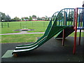
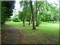
Playground in Seears Park
Seears Park is the formal area to the south of the woods of Perretts Field. The interest of the park is somewhat limited, apart from the fact it has a playground and a view of the woods.
In this view, the houses in the distance are in Quarry Park Road.
Image: © Marathon
Taken: 11 Sep 2013
0.11 miles
2
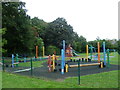
The playground in Seears Park
Seears Park is the formal area to the south of the woods of Perretts Field. The interest of the park is somewhat limited, apart from the fact it has a playground and a view of the woods, the entrance to the woods being seen behind the playground
Image: © Marathon
Taken: 11 Sep 2013
0.12 miles
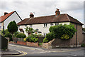
3
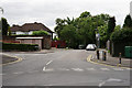
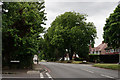
Quarry Road, Cheam
Located close to West Sutton railway station.
Image: © Peter Trimming
Taken: 9 Jun 2015
0.13 miles
4
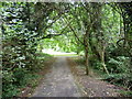
The woodland in Perretts Field
This small park is also known by local people as Seears Park, although Seears Park is just the formal area to the south of the woods. The north-western part, adjacent to St Dunstan's Hill (A24), is largely woodland with a few clearings, as here in the distance.
Image: © Marathon
Taken: 11 Sep 2013
0.13 miles
5
Perretts Field
This small park is also known by local people as Seears Park, although Seears Park is just the formal area to the south of the woods. The north-western part, adjacent to St Dunstan's Hill (A24), is largely woodland with a few clearings as here.
Image: © Marathon
Taken: 11 Sep 2013
0.15 miles
6
Bourne Way, Cheam
Seen from Gander Green Lane.
Image: © Peter Trimming
Taken: 9 Jun 2015
0.16 miles
7
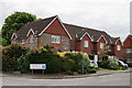
Shearwater Road, Cheam
Housing development, dating from 2000, seen from Gander Green Lane.
Image: © Peter Trimming
Taken: 9 Jun 2015
0.16 miles
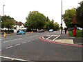
9
Cheam Road, Cheam
Looking in the direction of Cheam.
Image: © Peter Trimming
Taken: 9 Jun 2015
0.19 miles
10
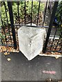
Milestone, Sutton
Carved stone post by the A232, in London Borough of Sutton, Cheam Road, by No. 135, opp. Carlisle Road, back to railings, set in pavement, on South side of road. Cheam stone erected by the Reigate Turnpike Trust in the 19th century.
Inscription reads: // WESTMINSTER / BRIDGE / XII / MILES // 1755 // CORNHILL / XIII / MILES //
Carved benchmark.
Milestone Society National ID: SY_LQRA12
Image: © Janet Dowding
Taken: 17 Oct 2020
0.19 miles