IMAGES TAKEN NEAR TO
Oxford Road, GERRARDS CROSS, SL9 8SZ
Introduction
This page details the photographs taken nearby to Oxford Road, SL9 8SZ by members of the Geograph project.
The Geograph project started in 2005 with the aim of publishing, organising and preserving representative images for every square kilometre of Great Britain, Ireland and the Isle of Man.

There are currently over 7.5m images from over14,400 individuals and you can help contribute to the project by visiting https://www.geograph.org.uk
Image Map
Images are licensed for reuse under creativecommons.org/licenses/by-sa/2.0
Notes
- Clicking on the map will re-center to the selected point.
- The higher the marker number, the further away the image location is from the centre of the postcode.
Image Listing (7 Images Found)
Images are licensed for reuse under creativecommons.org/licenses/by-sa/2.0
Image
Details
Distance
1
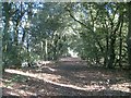
Gerrards Cross: Footpath to Hedgerley Green (3)
Following on from Image the footpath runs along a wide track through a wooded glade in Bulstrode Park.
Image: © Nigel Cox
Taken: 22 Dec 2013
0.08 miles
2
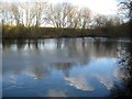
Gerrards Cross: Flooded pit near Bulstrode Park (2)
This pond is between Bulstrode Park and the sand and gravel pit workings around Moat Farm, and appears to have been created by allowing one of the worked out pits between the two to flood. The photographer disturbed a red kite perched low down in the trees around the pond during this visit.
Image: © Nigel Cox
Taken: 22 Dec 2013
0.08 miles
3
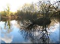
Gerrards Cross: Flooded pit near Bulstrode Park (1)
This pond is between Bulstrode Park and the sand and gravel pit workings around Moat Farm, and appears to have been created by allowing one of the worked out pits between the two to flood. The photographer disturbed a red kite perched low down in the trees around the pond during this visit.
Image: © Nigel Cox
Taken: 22 Dec 2013
0.11 miles
4
Bulstrode Park
Looking towards Gerrard's Cross. A large house on Main Drive can be seen.
Image: © Andrew Smith
Taken: 29 Apr 2006
0.21 miles
5
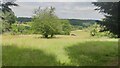
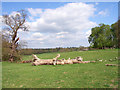
Farmland near Jerretts Hill
This land was sold off to the local farmers when Bulstrode was sold in the 1950's.
Image: © James Emmans
Taken: 23 Jun 2021
0.23 miles
6
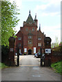
Bulstrode
The UK headquarters of WEC (World Evangelization for Christ) International, a Christian charity. The former house was rebuilt by the 12th Duke of Somerset in 1865.
Image: © Andrew Smith
Taken: 29 Apr 2006
0.23 miles
7
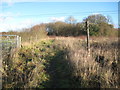
Gerrards Cross: Footpath to Hedgerley Green (2)
This footpath can be traced on the old Victorian Ordnance Survey map of 1875, but the whole area today would be unrecognisable to anyone from then with the building of the nearby M40 Motorway and the massive sand and gravel workings in the area. The view here is looking in the direction of Gerrards Cross where the path eventually runs around the north side of Bulstrode Manor Farm.
Image: © Nigel Cox
Taken: 22 Dec 2013
0.24 miles