IMAGES TAKEN NEAR TO
Portland Park, GERRARDS CROSS, SL9 7PX
Introduction
This page details the photographs taken nearby to Portland Park, SL9 7PX by members of the Geograph project.
The Geograph project started in 2005 with the aim of publishing, organising and preserving representative images for every square kilometre of Great Britain, Ireland and the Isle of Man.

There are currently over 7.5m images from over14,400 individuals and you can help contribute to the project by visiting https://www.geograph.org.uk
Image Map
Images are licensed for reuse under creativecommons.org/licenses/by-sa/2.0
Notes
- Clicking on the map will re-center to the selected point.
- The higher the marker number, the further away the image location is from the centre of the postcode.
Image Listing (42 Images Found)
Images are licensed for reuse under creativecommons.org/licenses/by-sa/2.0
Image
Details
Distance
1
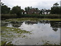
New Pond
New Pond Gerrards Cross Common
Image: © Shaun Ferguson
Taken: 7 Aug 2009
0.04 miles
3
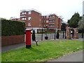
Flats off Oxford Road, Gerrards Cross
Showing position of Postbox No. SL9 114.
See Image] for postbox.
Image: © JThomas
Taken: 13 Apr 2019
0.08 miles
5
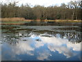
Gerrards Cross: New Pond
The pond is on Gerrards Cross Common next to the A40 Oxford Road. A 1999 ecology report can be found here http://www.pondconservation.org.uk/Resources/Pond%20Conservation/Documents/PDF/Gerrards%20Cross%20report%201999.pdf
Image: © Nigel Cox
Taken: 22 Dec 2013
0.08 miles
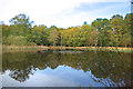
6
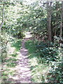
Woodland on Gerrards Cross Common
The common is partly open grassland and partly woodland with paths through. This photo is taken from the B416, between the A40 and the town centre.
Image: © David Hawgood
Taken: 22 Jun 2005
0.09 miles
7
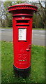
George VI postbox on Oxford Road, Gerrards Cross
Postbox No. SL9 114.
See Image] for context.
Image: © JThomas
Taken: 13 Apr 2019
0.09 miles
8
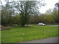
Gerrards Cross Common overlooking Packhorse Road
Image: © David Howard
Taken: 13 Apr 2011
0.10 miles
9
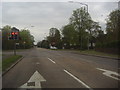
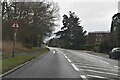
Junction of A40 and B416, Gerrards Cross
Image: © David Howard
Taken: 13 Apr 2011
0.10 miles
10
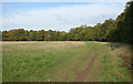
Trees round Bulstrode Camp
Bulstrode Camp is the largest Iron Age site in Buckinghamshire. The earthworks are hidden under a line of woodland and the interior is a grassy meadow. The line of the walls around the north east section is shown here.
Image: © Des Blenkinsopp
Taken: 30 Oct 2019
0.11 miles