IMAGES TAKEN NEAR TO
Coldmoorholme Lane, BOURNE END, SL8 5PR
Introduction
This page details the photographs taken nearby to Coldmoorholme Lane, SL8 5PR by members of the Geograph project.
The Geograph project started in 2005 with the aim of publishing, organising and preserving representative images for every square kilometre of Great Britain, Ireland and the Isle of Man.

There are currently over 7.5m images from over14,400 individuals and you can help contribute to the project by visiting https://www.geograph.org.uk
Image Map
Images are licensed for reuse under creativecommons.org/licenses/by-sa/2.0
Notes
- Clicking on the map will re-center to the selected point.
- The higher the marker number, the further away the image location is from the centre of the postcode.
Image Listing (15 Images Found)
Images are licensed for reuse under creativecommons.org/licenses/by-sa/2.0
Image
Details
Distance
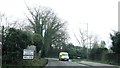
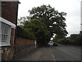
1

Coldmoorholme Lane at the junction of Marlow Road
Image: © David Howard
Taken: 8 Jan 2018
0.01 miles
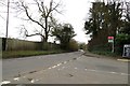
2
A4155 eastbound, entrance to Bourne End
Image: © Alex McGregor
Taken: 12 Mar 2014
0.02 miles
7
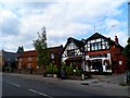
The Black Lion, Bourne End
Next door but one (far left of the picture) appears to be a disused chapel converted into a house.
Image: © Bikeboy
Taken: 21 Sep 2014
0.17 miles
8
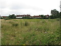
Houses on Coldmoorhome Lane seen across field
View from public footpath across rough pasture near Spade Oak, Little Marlow.
Image: © David Hawgood
Taken: 14 Jul 2021
0.18 miles
9
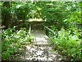
Path over Footbridge in Spade Oak Nature Reserve
Path away from lake and towards aggregates works at Spade Oak Local Nature Reserve. This is on the route of the London Green Belt Way.
Image: © Sean Davis
Taken: 28 Jul 2007
0.18 miles
10
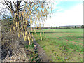
Catkins by the Path
The top end of a short walk around Spade Oak Lake, an old gravel pit now a nature reserve.
Image: © Des Blenkinsopp
Taken: 20 Feb 2017
0.20 miles