IMAGES TAKEN NEAR TO
Marlow Bottom, MARLOW, SL7 3PZ
Introduction
This page details the photographs taken nearby to Marlow Bottom, SL7 3PZ by members of the Geograph project.
The Geograph project started in 2005 with the aim of publishing, organising and preserving representative images for every square kilometre of Great Britain, Ireland and the Isle of Man.

There are currently over 7.5m images from over14,400 individuals and you can help contribute to the project by visiting https://www.geograph.org.uk
Image Map
Images are licensed for reuse under creativecommons.org/licenses/by-sa/2.0
Notes
- Clicking on the map will re-center to the selected point.
- The higher the marker number, the further away the image location is from the centre of the postcode.
Image Listing (6 Images Found)
Images are licensed for reuse under creativecommons.org/licenses/by-sa/2.0
Image
Details
Distance
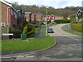
1

Marlow Bottom & Badgers Way
Very much the edge of town here, with housing along the valley floor, but woodland not far away.
Badgers Way is the road off to the right by the bend. I only mention this because it's such a predictable name for a road in this sort of area.
Badgers inevitably seem to be implicated in street naming where countryside has recently been built over.
Far more so than Toads, Rabbits and Snakes, which are all equally disturbed by the construction process but are somehow less respectable.
Image: © Des Blenkinsopp
Taken: 20 Apr 2013
0.18 miles
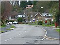
2
Highwoods, Drive, Marlow Bottom
The bounds of the village are mostly defined by the valley from which it takes its name. Highwoods Drive climbs slightly beneath woodland on this side. There is more development higher up on the other side of the valley.
Image: © Andrew Smith
Taken: 29 Mar 2008
0.18 miles
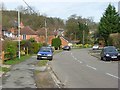
3
Marlow Bottom
This is the main road, also called Marlow Bottom, that follows the curves of the valley. This is the view from the junction with Highwoods Drive.
Image: © Andrew Smith
Taken: 29 Mar 2008
0.21 miles
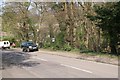
4
Marlow Bottom
The name of the village, road and valley.
Image: © Andrew Smith
Taken: 29 Mar 2008
0.21 miles
5
Marlow Bottom
Munces Wood - a tiny area of woodland in a busy residential area.
Image: © Brendan and Ruth McCartney
Taken: 21 Apr 2004
0.22 miles
6
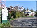
Marlow Bottom Methodist Church
Located at 148 Marlow Bottom Road, SL7 3PP, this Church is one of twelve in the High Wycombe Methodist Circuit. The notice on the left says that it is in an Anglican/Methodist Partnership serving Marlow Bottom.
Image: © David Hillas
Taken: 13 Apr 2010
0.24 miles