IMAGES TAKEN NEAR TO
Bridge Road, MAIDENHEAD, SL6 8LP
Introduction
This page details the photographs taken nearby to Bridge Road, SL6 8LP by members of the Geograph project.
The Geograph project started in 2005 with the aim of publishing, organising and preserving representative images for every square kilometre of Great Britain, Ireland and the Isle of Man.

There are currently over 7.5m images from over14,400 individuals and you can help contribute to the project by visiting https://www.geograph.org.uk
Image Map
Images are licensed for reuse under creativecommons.org/licenses/by-sa/2.0
Notes
- Clicking on the map will re-center to the selected point.
- The higher the marker number, the further away the image location is from the centre of the postcode.
Image Listing (116 Images Found)
Images are licensed for reuse under creativecommons.org/licenses/by-sa/2.0
Image
Details
Distance
1
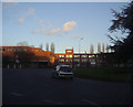
Maidenhead police station
On the A4 roundabout, Saint-Cloud Way
Image: © David Howard
Taken: 19 Feb 2012
0.04 miles
2
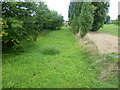
Strand Water at Maidenhead
The Cut connects to the River Thames and retains public navigation rights, though it is impractical for boats to pass through the sections in Miadenhead today as they are silted up and overgrown. The old channel leaves the Thames just above Cliveden and eventually rejoins it just below Bray Lock by the Marina. This part is known as Strand Water and acts as a flood relief channel. It is seen here from Bridge Road and at the time was dry. For more about the Maidenhead Waterways see http://en.wikipedia.org/wiki/Maidenhead_Waterways
Image: © Marathon
Taken: 22 Sep 2013
0.05 miles
3
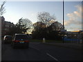
Roundabout on Bridge Road, Maidenhead
At the junction of Fourlease Road
Image: © David Howard
Taken: 19 Feb 2012
0.05 miles
4
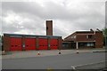
Maidenhead Fire Station
Maidenhead Fire Station, Bridge Road, Maidenhead, Berkshire
Image: © Kevin Hale
Taken: 8 May 2007
0.05 miles
5

Saint-Cloud Way (2)
This is the view east from the high footbridge. The large building on the left is the Magnet Leisure Centre.
Image: © Shazz
Taken: 31 Aug 2013
0.07 miles
6
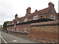
Salters' Company Almshouses at Maidenhead
Founded by James Smith in 1661. More information here: http://www.salters.co.uk/company/charalms.html
Image: © Rod Allday
Taken: 27 Aug 2008
0.08 miles
7
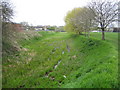
Maidenhead Flood Relief Channel
Viewed looking upstream here, the channel is normally dry with only a few puddles and shallow pools.
Image: © Nigel Cox
Taken: 19 Apr 2006
0.08 miles
8
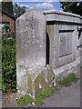
Old Milestone by the former A4, Moorbridge, Maidenhead
Carved stone post by the former A4, in parish of Maidenhead (Windsor and Maidenhead District), Moorbridge Road; opposite the Heritage Centre by Moor Bridge, West end of bridge over White Brook, in line with bridge parapet, 20yds east of Waitrose store, on North side of road. Bath Road limestone pillar, erected by the Maidenhead turnpike trust in the 19th century.
Inscription reads:-
: TO / READING / 13 / MILES / BATH / (82) / HENLEY / (9) / OXFORD / (32) : : COOKHAM PARISH : : TO / HYDE PARK / CORNER / 26 / MILES / COLNBROOK / 9 :
Grade II listed.
List Entry Number: 1319372 https://historicengland.org.uk/listing/the-list/list-entry/1319372
Milestone Society National ID: BE_LB26
Image: © A Rosevear
Taken: 18 Jan 2002
0.09 miles
9
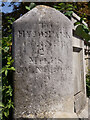
Maidenhead : milestone
Grade II listed - https://historicengland.org.uk/listing/the-list/list-entry/1319372?section=official-list-entry
Image: © Jim Osley
Taken: 12 Aug 2022
0.09 miles
10
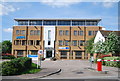
ARM, Maidenhead
Makers of Chips for Mobile phones.
Image: © N Chadwick
Taken: 26 May 2013
0.09 miles