IMAGES TAKEN NEAR TO
Henley Road, MAIDENHEAD, SL6 5NQ
Introduction
This page details the photographs taken nearby to Henley Road, SL6 5NQ by members of the Geograph project.
The Geograph project started in 2005 with the aim of publishing, organising and preserving representative images for every square kilometre of Great Britain, Ireland and the Isle of Man.

There are currently over 7.5m images from over14,400 individuals and you can help contribute to the project by visiting https://www.geograph.org.uk
Image Map
Images are licensed for reuse under creativecommons.org/licenses/by-sa/2.0
Notes
- Clicking on the map will re-center to the selected point.
- The higher the marker number, the further away the image location is from the centre of the postcode.
Image Listing (14 Images Found)
Images are licensed for reuse under creativecommons.org/licenses/by-sa/2.0
Image
Details
Distance
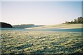
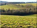
1
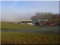
Barns, Rosehill
Belonging to the Juddmonte Farms. Above a misty Thames valley.
Image: © Andrew Smith
Taken: 25 Feb 2008
0.04 miles
2
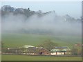
Barns, Rosehill
These nestle in a valley below Rosehill towards which we look.
Image: © Andrew Smith
Taken: 25 Feb 2008
0.04 miles
3
A Very Neat Landscape
It's got to be horses. No other animal commands such an immaculate habitat.
Image: © Des Blenkinsopp
Taken: 14 Apr 2014
0.07 miles
4
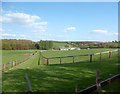
Paddocks, Rosehill
Looking northwards from the A4130 across the western flanks of a valley.
Image: © Andrew Smith
Taken: 23 Oct 2007
0.10 miles
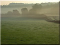
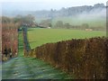
5
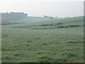
Frosty valley, Rosehill
Looking up a dry valley from the A4130
Image: © Andrew Smith
Taken: 17 Nov 2005
0.13 miles
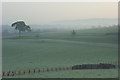
6
Woodland and paddock, Rosehill
In the area between Wargrave and Cookham a small range of chalk hills rise to the south of the Thames. A little mist had formed in the slight dry valleys.
Image: © Andrew Smith
Taken: 23 Oct 2007
0.15 miles
7
Frosty gallops, Rosehill
Much of the area is devoted to horses, with a Juddmonte Farms stud nearby.
Image: © Andrew Smith
Taken: 17 Nov 2005
0.16 miles
8
Paddocks, Rosehill
Looking across a valley from Rose Lane. The prominent tree stands beside the driveway running south from the A4130 parallel to the lane.
Image: © Andrew Smith
Taken: 23 Oct 2007
0.16 miles
9
Pasture, Hurley
Land grazed by the horses of Juddmonte Farms and some other livestock is viewed from a permitted footpath that crosses to Rose Lane.
Image: © Andrew Smith
Taken: 17 Feb 2015
0.18 miles
10
Rolling countryside, Hurley
Low chalk hills rise to the south of the Thames between Cookham and Wargrave. A large area of these to the southwest of Hurley is occupied by Juddmonte Farms who breed horses. These are amongst their fields.
Image: © Andrew Smith
Taken: 25 Feb 2008
0.18 miles