IMAGES TAKEN NEAR TO
Chestnut Park, MAIDENHEAD, SL6 2EF
Introduction
This page details the photographs taken nearby to Chestnut Park, SL6 2EF by members of the Geograph project.
The Geograph project started in 2005 with the aim of publishing, organising and preserving representative images for every square kilometre of Great Britain, Ireland and the Isle of Man.

There are currently over 7.5m images from over14,400 individuals and you can help contribute to the project by visiting https://www.geograph.org.uk
Image Map
Images are licensed for reuse under creativecommons.org/licenses/by-sa/2.0
Notes
- Clicking on the map will re-center to the selected point.
- The higher the marker number, the further away the image location is from the centre of the postcode.
Image Listing (30 Images Found)
Images are licensed for reuse under creativecommons.org/licenses/by-sa/2.0
Image
Details
Distance
1

Bray - New Estate in Monkey Island Lane
Image: © James Emmans
Taken: 11 Jun 2017
0.04 miles
2
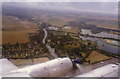
Monkey Island, Dorney Reach from the air
Monkey Island is the area bordered by the M4, the Thames and the lakes. Dorney Reach is the built-up area on the left.
This was taken from a Vickers Viscount during a flight in 1996 to commemorate the type's retirement from commercial service.
Image: © Stephen Williams
Taken: 29 Jul 1996
0.07 miles
3

Bray - House on Monkey Island Lane
Close to Monkey Island on the Thames.
Image: © James Emmans
Taken: 11 Jun 2017
0.08 miles
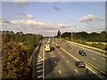
6
Bray : M4 Motorway
Heading along the M4 Motorway.
Image: © Lewis Clarke
Taken: 27 Jun 2022
0.17 miles
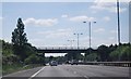
7

Windsor and Maidenhead : M4 Motorway
The M4 Motorway between Junction 8/9 (Holyport Interchange) and Junction 7 (Huntercombe Spur)
Image: © Lewis Clarke
Taken: 23 Mar 2018
0.17 miles
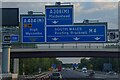
8
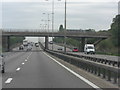
M4 approaches Monkey Island Lane overbridge
Do the road planners put these bridges on the edge of the square on purpose? Anyhow, the lane serves the island in the Thames of the same name and connects it to Bray.
Image: © Stuart Logan
Taken: 24 Aug 2011
0.17 miles
9
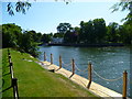
Orange Way after Wiltshire (438)
Monkey Island is seen across the water.
Image: © Shazz
Taken: 31 Aug 2013
0.18 miles