IMAGES TAKEN NEAR TO
Lower Village Road, ASCOT, SL5 7AU
Introduction
This page details the photographs taken nearby to Lower Village Road, SL5 7AU by members of the Geograph project.
The Geograph project started in 2005 with the aim of publishing, organising and preserving representative images for every square kilometre of Great Britain, Ireland and the Isle of Man.

There are currently over 7.5m images from over14,400 individuals and you can help contribute to the project by visiting https://www.geograph.org.uk
Image Map
Images are licensed for reuse under creativecommons.org/licenses/by-sa/2.0
Notes
- Clicking on the map will re-center to the selected point.
- The higher the marker number, the further away the image location is from the centre of the postcode.
Image Listing (24 Images Found)
Images are licensed for reuse under creativecommons.org/licenses/by-sa/2.0
Image
Details
Distance
1
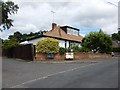
Bungalow on Lower Village Road
On the junction with Quince Close.
Image: © James Emmans
Taken: 21 Jul 2017
0.07 miles
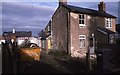
2
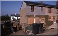
86 Upper Village Road Sunninghill
The extension was built in 1995, here nearing completion in October of that year. The Forge (to the left) has been demolished at this stage, but the new building has not yet been erected
Image: © Mick Crawley
Taken: 15 Oct 1995
0.08 miles
3
The Forge (86a) Upper Village Road during demolition
The site was cleared in June 1995
Image: © Mick Crawley
Taken: 14 Jun 1995
0.09 miles
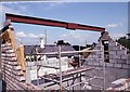
4
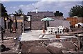
The Forge (86a) Upper Village Road under construction
In July 1996 the floor was laid out and the builders had installed a picnic area in what was to be the kitchen
Image: © Mick Crawley
Taken: 16 Jul 1996
0.09 miles
5
86 Upper Village Road Sunninghill before extension
The Forge (to the left) in the process of demolition in early 1995
Image: © Mick Crawley
Taken: 13 Feb 1995
0.09 miles
6
The Forge (86a) Upper Village Road was roofed in October 1996
Image: © Mick Crawley
Taken: 15 Oct 1996
0.09 miles
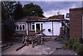
7
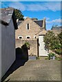
The Forge 86a Upper Village Road Sunninghill
The house was built 25 years ago following demolition of the original factory (The Forge). The climber on the right is Solanum jasminoides 'Album', still flowering profusely in October.
Image: © Mick Crawley
Taken: 6 Oct 2021
0.10 miles
8
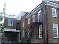
Ascot Telephone Exchange (2)
This photo shows the extension housing the digital equipment. Besides Ascot, this TE also serves South Ascot, Sunningdale and Sunninghill nearby. The postcode of this TE is SL5 7AJ.
Image: © David Hillas
Taken: 11 Jun 2011
0.11 miles
9

Ascot Telephone Exchange (3)
This photo shows the original TE and the extension behind it, which has a mobile phone aerial on its roof. Two BT Openreach vans can be seen parked in the distance whilst a KX100 telephone kiosk can just be seen at the extreme right of the photo.
Image: © David Hillas
Taken: 11 Jun 2011
0.11 miles
10
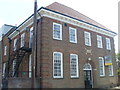
Ascot Telephone Exchange (1)
Situated in Upper Village Road, this redbrick building is the original Manual TE before automatic working arrived sometime during the late 1960s. The wording "TELEPHONE EXCHANGE" can be seen above the entrance door, whilst a black and yellow "To Let" board can be seen to the right of the photo. This would mean that this building is no longer in use, although the present TE is in the extension behind it.
Image: © David Hillas
Taken: 11 Jun 2011
0.11 miles