IMAGES TAKEN NEAR TO
Old House Court, Church Lane, SLOUGH, SL3 6LN
Introduction
This page details the photographs taken nearby to Old House Court, Church Lane, SL3 6LN by members of the Geograph project.
The Geograph project started in 2005 with the aim of publishing, organising and preserving representative images for every square kilometre of Great Britain, Ireland and the Isle of Man.

There are currently over 7.5m images from over14,400 individuals and you can help contribute to the project by visiting https://www.geograph.org.uk
Image Map
Images are licensed for reuse under creativecommons.org/licenses/by-sa/2.0
Notes
- Clicking on the map will re-center to the selected point.
- The higher the marker number, the further away the image location is from the centre of the postcode.
Image Listing (11 Images Found)
Images are licensed for reuse under creativecommons.org/licenses/by-sa/2.0
Image
Details
Distance

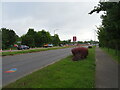
2
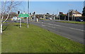
Junction of Uxbridge Road and Church Lane
Heading north-east on the A412 Uxbridge Road, urban Slough suddenly gives way to rural Buckinghamshire. The county boundary, redefined in 1974, runs along the southern side of Church Lane to our left.
Image: © Graham Horn
Taken: 23 Feb 2012
0.13 miles
3
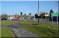
Junction of Uxbridge Road and Church Lane
Heading north-east on the A412 Uxbridge Road, urban Slough suddenly gives way to rural Buckinghamshire. The county boundary, redefined in 1974, runs along the southern side of Church Lane to our left.
Image: © Graham Horn
Taken: 23 Feb 2012
0.13 miles
6
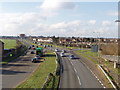
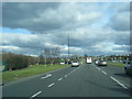
Outskirts of Slough
From a footbridge over the A412 Uxbridge Road, looking south-west to Upton Lea and Slough. The crash barrier in the middle of the dual carriageway looks as if it has done its job and been bent in stopping a vehicle crossing.
Image: © David Hawgood
Taken: 21 Feb 2006
0.16 miles
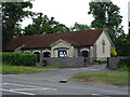
10
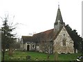
Wexham: St Mary's Church
The oldest part of the church, the nave, dates from the 12th century, and the circular opening in the west wall, visible here, dates from that time. Below it the two-light window dates from the 15th century. The bell tower has wooden weatherboarding and a wooden spire above.
The church appears to stand in isolation from any other contemporary buildings, but the manor house of Wexham Court, now demolished, used to stand on the other side of Church Lane. Today the Wexham Court housing estate covers the area of the manor house.
The church was formerly known as St Mary the Virgin and its website is here http://www.stmaryswexham.org.uk/
Image: © Nigel Cox
Taken: 8 Jan 2009
0.22 miles