IMAGES TAKEN NEAR TO
Middlegreen Road, SLOUGH, SL3 6BU
Introduction
This page details the photographs taken nearby to Middlegreen Road, SL3 6BU by members of the Geograph project.
The Geograph project started in 2005 with the aim of publishing, organising and preserving representative images for every square kilometre of Great Britain, Ireland and the Isle of Man.

There are currently over 7.5m images from over14,400 individuals and you can help contribute to the project by visiting https://www.geograph.org.uk
Image Map
Images are licensed for reuse under creativecommons.org/licenses/by-sa/2.0
Notes
- Clicking on the map will re-center to the selected point.
- The higher the marker number, the further away the image location is from the centre of the postcode.
Image Listing (10 Images Found)
Images are licensed for reuse under creativecommons.org/licenses/by-sa/2.0
Image
Details
Distance
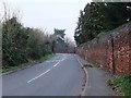
1
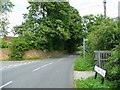
Road junction at Middle Green
Here St. Mary's Road meets Middlegreen Road to the north-east of Slough.
The bridleway to the right seems to be little used.
Image: © Jonathan Billinger
Taken: 19 Jun 2008
0.07 miles
2
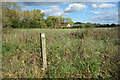
Waymark in the Long Grass
This must have been along the line of the path at one time but the field doesn't seem to be used for anything at the moment and the path has found a slightly different route.
Image: © Des Blenkinsopp
Taken: 5 Oct 2017
0.10 miles
3
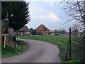
Old farm building south of Middle Green
The minor road from which this shot was taken is bounded on its west side by a substantial old 'estate' wall (to be seen in http://www.geograph.org.uk/photo/2309524). I suspect there was once an extensive farmyard here, but the little red-brick building in the middle of the picture was the only trace I could find. It stands at the western margin of the grid-square.
Much of the land is now horse pasture, and there are riding stables nearby.
In the right foreground, blossom is out on the blackthorn hedge.
Image: © Stefan Czapski
Taken: 15 Mar 2011
0.10 miles
4
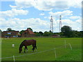
Paddock land at Middlegreen
The horse appears undisturbed by the planes taking off from Heathrow nearby.
Image: © Jonathan Billinger
Taken: 19 Jun 2008
0.10 miles
5
The road to Langley Marish from Middle Green
Looking south from near the road junction shown in Jonathan Billinger's Image The one point of interest is the old brick wall. I suspect there was once a substantial farmhouse (a 'Manor Farm' ?) somewhere nearby. All that seems to be left is a minor farm building, a little further west.
Image: © Stefan Czapski
Taken: 15 Mar 2011
0.10 miles
6
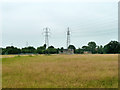
Field east of Middlegreen Road
The power lines connect the Slough area to Iver substation.
Image: © Robin Webster
Taken: 21 Jul 2013
0.17 miles
7
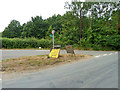
Junction of Middlegreen Road and Nursery Lane
The diversion sign appears to send traffic down Nursery Lane, which is a dead end. It is probably meant to direct traffic emerging from Nursery Lane. Middlegreen Road was temporarily closed some way behind the camera at the railway bridge.
Image: © Robin Webster
Taken: 21 Jul 2013
0.21 miles
8
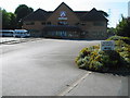
Langley Manor School
This is an independent school for children aged 2-11. Although it is called "Langley", it is actually outside the borough boundary, and part of Middlegreen. The rest of this square is taken up with farmland and some large houses.
Image: © Darren Smith
Taken: 10 Jul 2005
0.23 miles
9
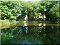
Orange Way after Wiltshire (475)
The Orange Way has entered its fifth and final myriad. This wide bit of the canal must be some sort of layby for boats.
Image: © Shazz
Taken: 4 Sep 2013
0.25 miles
10
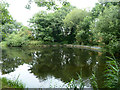
Winding hole, Slough Arm, Grand Union Canal
There never seems to have been a wharf on the far bank here, but there was one on the towpath side (roughly at the camera position), connected by tramway over the railway to a brickworks. So perhaps brick boats winded here.
Image: © Robin Webster
Taken: 21 Jul 2013
0.25 miles