IMAGES TAKEN NEAR TO
Pickfords Gardens, SLOUGH, SL1 3GQ
Introduction
This page details the photographs taken nearby to Pickfords Gardens, SL1 3GQ by members of the Geograph project.
The Geograph project started in 2005 with the aim of publishing, organising and preserving representative images for every square kilometre of Great Britain, Ireland and the Isle of Man.

There are currently over 7.5m images from over14,400 individuals and you can help contribute to the project by visiting https://www.geograph.org.uk
Image Map
Images are licensed for reuse under creativecommons.org/licenses/by-sa/2.0
Notes
- Clicking on the map will re-center to the selected point.
- The higher the marker number, the further away the image location is from the centre of the postcode.
Image Listing (38 Images Found)
Images are licensed for reuse under creativecommons.org/licenses/by-sa/2.0
Image
Details
Distance
2
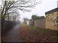
Footpath, Salt Hill
The path runs parallel to Baylis Road (right), connecting Stoke Poges Lane to Baylis Grounds.
Image: © Derek Harper
Taken: 19 Nov 2010
0.03 miles
4
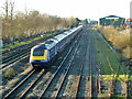
Down fast train west of Slough
It is unusually running on the relief lines as the main lines to the left are closed for engineering work somewhere ahead. Both of the main lines have temporary red stop boards in the 'four-foot' - one may be seen at the left.
Image: © Robin Webster
Taken: 19 Jan 2014
0.07 miles
5
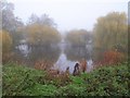
Baylis Pond
A view of Image seen from the other side near Woodlands Avenue.
Image: © Derek Harper
Taken: 19 Nov 2010
0.11 miles
6
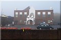
Ramgarhia Sikh Gurdwara
This Sikh temple is by Woodlands Avenue opposite Baylis Grounds.
Image: © Derek Harper
Taken: 19 Nov 2010
0.11 miles
7
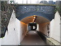
Slough: Salt Hill Park subway
The subway links Salt Hill Park and Baylis Road under the former Great Western Railway's main line. There are actually two subways here. The far one is the earlier and still carries the main line. The nearer one was built to accommodate a head shunt for the sidings serving Image The trackwork has however long since been removed from this. However the original, and still continuing function, of this hole through the railway embankment was to allow the passage of Salt Hill Stream, which is now culverted itself under the subway.
Image: © Nigel Cox
Taken: 8 Jan 2009
0.12 miles
8
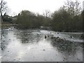
Slough: Baylis Pond
Ducks struggle to cope with a frozen surface after a cold January night.
Baylis Pond is in what used to be the grounds of Baylis House which now form a public park. The 1881 Edition of the Ordnance Survey mapping shows the pond with a far more formal rectangular shape. At some point the south-western corner has been filled in, all the other corners rounded off, and some bird-nesting islands introduced.
Image: © Nigel Cox
Taken: 8 Jan 2009
0.12 miles
9
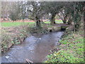
Salt Hill Stream in Salt Hill Park, Slough
Viewed looking upstream at the end of the culvert under the railway.
Image: © Nigel Cox
Taken: 8 Jan 2009
0.15 miles