IMAGES TAKEN NEAR TO
Bathurst Walk, IVER, SL0 9DG
Introduction
This page details the photographs taken nearby to Bathurst Walk, SL0 9DG by members of the Geograph project.
The Geograph project started in 2005 with the aim of publishing, organising and preserving representative images for every square kilometre of Great Britain, Ireland and the Isle of Man.

There are currently over 7.5m images from over14,400 individuals and you can help contribute to the project by visiting https://www.geograph.org.uk
Image Map
Images are licensed for reuse under creativecommons.org/licenses/by-sa/2.0
Notes
- Clicking on the map will re-center to the selected point.
- The higher the marker number, the further away the image location is from the centre of the postcode.
Image Listing (42 Images Found)
Images are licensed for reuse under creativecommons.org/licenses/by-sa/2.0
Image
Details
Distance
2
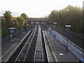
Iver Station
Iver Station looking East towards Thorney Lane South bridge
Image: © Shaun Ferguson
Taken: 17 Oct 2014
0.06 miles
3
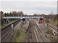
Iver Station
Taken looking west from Thorney Lane. The railway line is from London Paddington to Slough and the West.
Image: © David Hawgood
Taken: 17 Jan 2006
0.07 miles
4
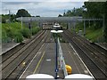
Iver railway station, Richings Park
Iver railway station, which really is in Richings Park. Looking east towards the new road bridge for Thorney Lane South. A higher bridge was needed for the Crossrail project.
Image: © Rob Emms
Taken: 4 Jul 2016
0.07 miles
6
Bathurst Walk, Iver
Houses on the north side, near Thorney Lane.
Image: © David Hawgood
Taken: 21 Jan 2006
0.08 miles
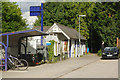
7
Iver Delivery Office, Royal Mail
On the corner of Thorney lane and Bathurst Walk. The Post Office has two types of sorting office, usually larger ones for sorting of collected mail, ones like this for sorting into individual delivery walks (or bicycle or van rides).
Image: © David Hawgood
Taken: 21 Jan 2006
0.08 miles
8
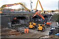
Demolition of Brunel's bridge over the GWR at Iver
Taken in the afternoon of Christmas Day, 2014. It was not possible to fit the overhead lines beneath the arches, so a new bridge was required. By the following morning, most of the bridge was gone. The remains of the pillars have been incorporated into the new bridge.
Image: © Roger Muggleton
Taken: 25 Dec 2014
0.08 miles
9
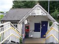
Iver railway station's ticket office. (1)
Part-time ticket office for Iver's railway station.
Image: © Rob Emms
Taken: 4 Jul 2016
0.08 miles
10
Iver Station
The station at Iver, which should perhaps more accurately be named Richings Park, was opened in 1924 - some 86 years after the GWR main line. It has long enjoyed a relatively quiet existence in a semi-rural area between the London suburbs and Slough, but from 2019 it will become a stop on the Elizabeth Line offering through journeys across London.
Image: © Stephen McKay
Taken: 15 Aug 2017
0.08 miles